You are here: Home > Network List > NE - New England Seismic Network Stations List
> Station YLE Yale, Connecticut, U.S.A. > Earthquake Result Viewer
YLE Yale, Connecticut, U.S.A. - Earthquake Result Viewer
| Earthquake location: |
Gulf Of Alaska |
| Earthquake latitude/longitude: |
56.0/-149.1 |
| Earthquake time(UTC): |
2018/01/23 (023) 09:31:42 GMT |
| Earthquake Depth: |
25 km |
| Earthquake Magnitude: |
7.9 Mww |
| Earthquake Catalog/Contributor: |
NEIC PDE/us |
|
| Network: |
NE New England Seismic Network |
| Station: |
YLE Yale, Connecticut, U.S.A. |
| Lat/Lon: |
41.32 N/72.92 W |
| Elevation: |
41 m |
|
| Distance: |
49.8 deg |
| Az: |
73.269 deg |
| Baz: |
314.487 deg |
| Ray Param: |
0.0684395 |
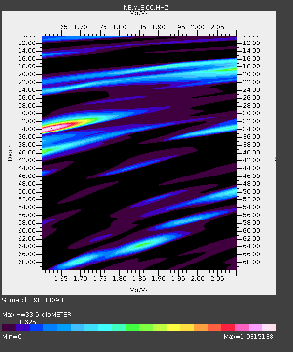
| Estimated Moho Depth: |
33.5 km |
| Estimated Crust Vp/Vs: |
1.62 |
| Assumed Crust Vp: |
6.472 km/s |
| Estimated Crust Vs: |
3.983 km/s |
| Estimated Crust Poisson's Ratio: |
0.20 |
|
| Radial Match: |
98.83098 % |
| Radial Bump: |
322 |
| Transverse Match: |
94.35396 % |
| Transverse Bump: |
400 |
| SOD ConfigId: |
2973751 |
| Insert Time: |
2018-10-09 06:10:05.380 +0000 |
| GWidth: |
2.5 |
| Max Bumps: |
400 |
| Tol: |
0.001 |
|

Signal To Noise
| Channel | StoN | STA | LTA |
| NE:YLE:00:HHZ:20180123T09:40:02.618986Z | 2.1122215 | 1.2123828E-6 | 5.7398466E-7 |
| NE:YLE:00:HH1:20180123T09:40:02.618986Z | 1.6540735 | 8.4071473E-7 | 5.0826924E-7 |
| NE:YLE:00:HH2:20180123T09:40:02.618986Z | 1.725489 | 8.428569E-7 | 4.884742E-7 |
| Arrivals |
| Ps | 3.5 SECOND |
| PpPs | 13 SECOND |
| PsPs/PpSs | 16 SECOND |


