You are here: Home > Network List > IC - New China Digital Seismograph Network Stations List
> Station KMI Kunming, Yunnan Province, China > Earthquake Result Viewer
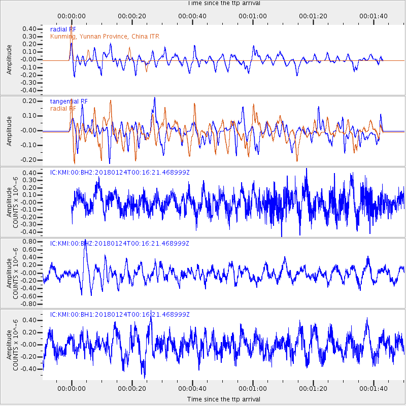
KMI Kunming, Yunnan Province, China - Earthquake Result Viewer
*The percent match for this event was below the threshold and hence no stack was calculated.
| Earthquake location: |
Gulf Of Alaska |
| Earthquake latitude/longitude: |
56.5/-148.5 |
| Earthquake time(UTC): |
2018/01/24 (024) 00:04:48 GMT |
| Earthquake Depth: |
10 km |
| Earthquake Magnitude: |
5.5 Mww |
| Earthquake Catalog/Contributor: |
NEIC PDE/us |
|
| Network: |
IC New China Digital Seismograph Network |
| Station: |
KMI Kunming, Yunnan Province, China |
| Lat/Lon: |
25.12 N/102.74 E |
| Elevation: |
1975 m |
|
| Distance: |
79.0 deg |
| Az: |
299.032 deg |
| Baz: |
32.302 deg |
| Ray Param: |
$rayparam |
*The percent match for this event was below the threshold and hence was not used in the summary stack. |
|
| Radial Match: |
56.94483 % |
| Radial Bump: |
400 |
| Transverse Match: |
67.800545 % |
| Transverse Bump: |
400 |
| SOD ConfigId: |
2973751 |
| Insert Time: |
2018-10-09 06:23:22.785 +0000 |
| GWidth: |
2.5 |
| Max Bumps: |
400 |
| Tol: |
0.001 |
|
Signal To Noise
| Channel | StoN | STA | LTA |
| IC:KMI:00:BHZ:20180124T00:16:21.468999Z | 2.3525937 | 3.3789536E-7 | 1.4362674E-7 |
| IC:KMI:00:BH1:20180124T00:16:21.468999Z | 0.85208315 | 1.1627407E-7 | 1.364586E-7 |
| IC:KMI:00:BH2:20180124T00:16:21.468999Z | 0.7691388 | 8.796326E-8 | 1.14365896E-7 |
| Arrivals |
| Ps | |
| PpPs | |
| PsPs/PpSs | |


