You are here: Home > Network List > XA95 - Missouri to Massachusetts Transect Stations List
> Station MM16 Lake Newton, Illinois > Earthquake Result Viewer
MM16 Lake Newton, Illinois - Earthquake Result Viewer

| Earthquake location: |
Sakhalin, Russia |
| Earthquake latitude/longitude: |
52.6/142.8 |
| Earthquake time(UTC): |
1995/05/27 (147) 13:03:55 GMT |
| Earthquake Depth: |
33 km |
| Earthquake Magnitude: |
6.6 MB, 7.6 MS, 7.0 UNKNOWN, 7.0 MW |
| Earthquake Catalog/Contributor: |
WHDF/NEIC |
|
| Network: |
XA Missouri to Massachusetts Transect |
| Station: |
MM16 Lake Newton, Illinois |
| Lat/Lon: |
38.92 N/88.30 W |
| Elevation: |
165 m |
|
| Distance: |
78.7 deg |
| Az: |
38.267 deg |
| Baz: |
331.009 deg |
| Ray Param: |
0.049446903 |
| Estimated Moho Depth: |
53.0 km |
| Estimated Crust Vp/Vs: |
1.67 |
| Assumed Crust Vp: |
6.444 km/s |
| Estimated Crust Vs: |
3.864 km/s |
| Estimated Crust Poisson's Ratio: |
0.22 |
|
| Radial Match: |
86.58644 % |
| Radial Bump: |
400 |
| Transverse Match: |
72.88869 % |
| Transverse Bump: |
400 |
| SOD ConfigId: |
6273 |
| Insert Time: |
2010-02-26 17:55:13.034 +0000 |
| GWidth: |
2.5 |
| Max Bumps: |
400 |
| Tol: |
0.001 |
|
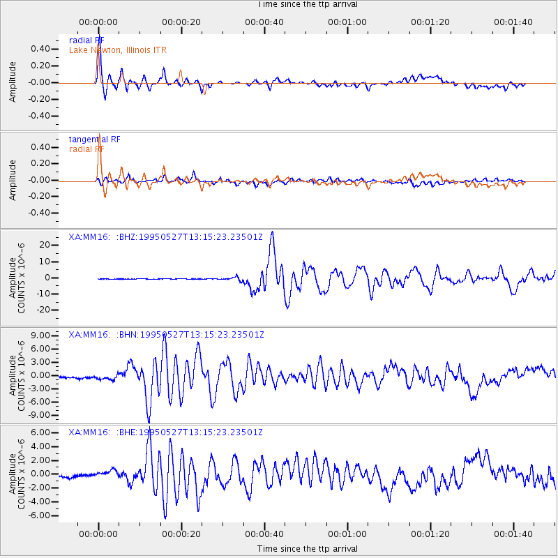
Signal To Noise
| Channel | StoN | STA | LTA |
| XA:MM16: :BHN:19950527T13:15:23.23501Z | 2.2038417 | 8.058631E-7 | 3.6566288E-7 |
| XA:MM16: :BHE:19950527T13:15:23.23501Z | 3.7305112 | 7.915002E-7 | 2.1216937E-7 |
| XA:MM16: :BHZ:19950527T13:15:23.23501Z | 9.697427 | 1.0672511E-6 | 1.1005508E-7 |
| Arrivals |
| Ps | 5.7 SECOND |
| PpPs | 21 SECOND |
| PsPs/PpSs | 27 SECOND |


