You are here: Home > Network List > TA - USArray Transportable Network (new EarthScope stations) Stations List
> Station H20A Greybull, WY, USA > Earthquake Result Viewer
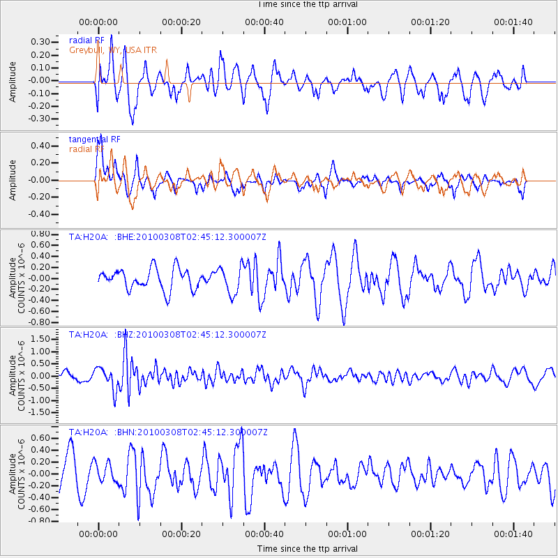
H20A Greybull, WY, USA - Earthquake Result Viewer
*The percent match for this event was below the threshold and hence no stack was calculated.
| Earthquake location: |
Turkey |
| Earthquake latitude/longitude: |
38.9/40.0 |
| Earthquake time(UTC): |
2010/03/08 (067) 02:32:34 GMT |
| Earthquake Depth: |
12 km |
| Earthquake Magnitude: |
5.9 MB, 6.0 MS, 6.1 MW, 6.1 MW |
| Earthquake Catalog/Contributor: |
WHDF/NEIC |
|
| Network: |
TA USArray Transportable Network (new EarthScope stations) |
| Station: |
H20A Greybull, WY, USA |
| Lat/Lon: |
44.49 N/108.00 W |
| Elevation: |
1236 m |
|
| Distance: |
92.1 deg |
| Az: |
337.684 deg |
| Baz: |
24.465 deg |
| Ray Param: |
$rayparam |
*The percent match for this event was below the threshold and hence was not used in the summary stack. |
|
| Radial Match: |
57.36813 % |
| Radial Bump: |
400 |
| Transverse Match: |
59.342052 % |
| Transverse Bump: |
368 |
| SOD ConfigId: |
299721 |
| Insert Time: |
2010-04-26 19:00:34.703 +0000 |
| GWidth: |
2.5 |
| Max Bumps: |
400 |
| Tol: |
0.001 |
|
Signal To Noise
| Channel | StoN | STA | LTA |
| TA:H20A: :BHZ:20100308T02:45:12.300007Z | 3.0891314 | 4.6384739E-7 | 1.5015463E-7 |
| TA:H20A: :BHN:20100308T02:45:12.300007Z | 0.5930699 | 1.5344833E-7 | 2.5873564E-7 |
| TA:H20A: :BHE:20100308T02:45:12.300007Z | 1.3803675 | 2.5683482E-7 | 1.8606264E-7 |
| Arrivals |
| Ps | |
| PpPs | |
| PsPs/PpSs | |


