You are here: Home > Network List > TA - USArray Transportable Network (new EarthScope stations) Stations List
> Station J21A Lysite, WY, USA > Earthquake Result Viewer
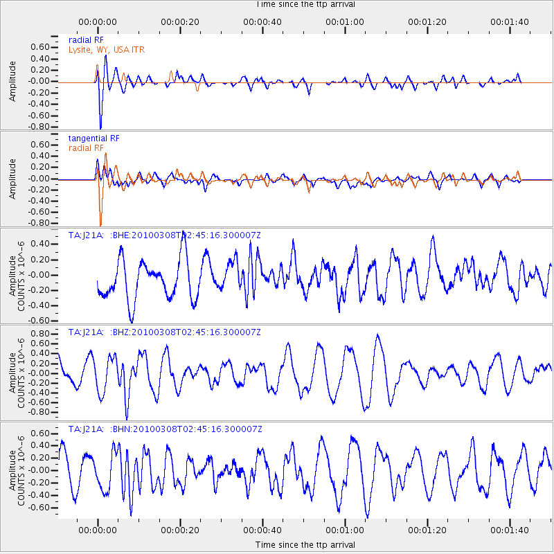
J21A Lysite, WY, USA - Earthquake Result Viewer
*The percent match for this event was below the threshold and hence no stack was calculated.
| Earthquake location: |
Turkey |
| Earthquake latitude/longitude: |
38.9/40.0 |
| Earthquake time(UTC): |
2010/03/08 (067) 02:32:34 GMT |
| Earthquake Depth: |
12 km |
| Earthquake Magnitude: |
5.9 MB, 6.0 MS, 6.1 MW, 6.1 MW |
| Earthquake Catalog/Contributor: |
WHDF/NEIC |
|
| Network: |
TA USArray Transportable Network (new EarthScope stations) |
| Station: |
J21A Lysite, WY, USA |
| Lat/Lon: |
43.35 N/107.45 W |
| Elevation: |
1913 m |
|
| Distance: |
93.0 deg |
| Az: |
336.844 deg |
| Baz: |
24.885 deg |
| Ray Param: |
$rayparam |
*The percent match for this event was below the threshold and hence was not used in the summary stack. |
|
| Radial Match: |
77.90277 % |
| Radial Bump: |
400 |
| Transverse Match: |
50.557827 % |
| Transverse Bump: |
400 |
| SOD ConfigId: |
299721 |
| Insert Time: |
2010-04-26 19:00:37.111 +0000 |
| GWidth: |
2.5 |
| Max Bumps: |
400 |
| Tol: |
0.001 |
|
Signal To Noise
| Channel | StoN | STA | LTA |
| TA:J21A: :BHZ:20100308T02:45:16.300007Z | 1.4010646 | 3.5128957E-7 | 2.5073044E-7 |
| TA:J21A: :BHN:20100308T02:45:16.300007Z | 1.511436 | 3.024795E-7 | 2.0012723E-7 |
| TA:J21A: :BHE:20100308T02:45:16.300007Z | 0.76913893 | 1.9569453E-7 | 2.5443325E-7 |
| Arrivals |
| Ps | |
| PpPs | |
| PsPs/PpSs | |


