You are here: Home > Network List > AV - Alaska Volcano Observatory Stations List
> Station CESW Southwest, Cerberus Volcano, Alaska > Earthquake Result Viewer
CESW Southwest, Cerberus Volcano, Alaska - Earthquake Result Viewer
| Earthquake location: |
Near Coast Of Northern Calif. |
| Earthquake latitude/longitude: |
40.5/-124.4 |
| Earthquake time(UTC): |
2022/12/20 (354) 10:34:24 GMT |
| Earthquake Depth: |
18 km |
| Earthquake Magnitude: |
6.4 mw |
| Earthquake Catalog/Contributor: |
NEIC PDE/nc |
|
| Network: |
AV Alaska Volcano Observatory |
| Station: |
CESW Southwest, Cerberus Volcano, Alaska |
| Lat/Lon: |
51.90 N/179.56 E |
| Elevation: |
238 m |
|
| Distance: |
39.5 deg |
| Az: |
306.064 deg |
| Baz: |
83.985 deg |
| Ray Param: |
0.07495851 |
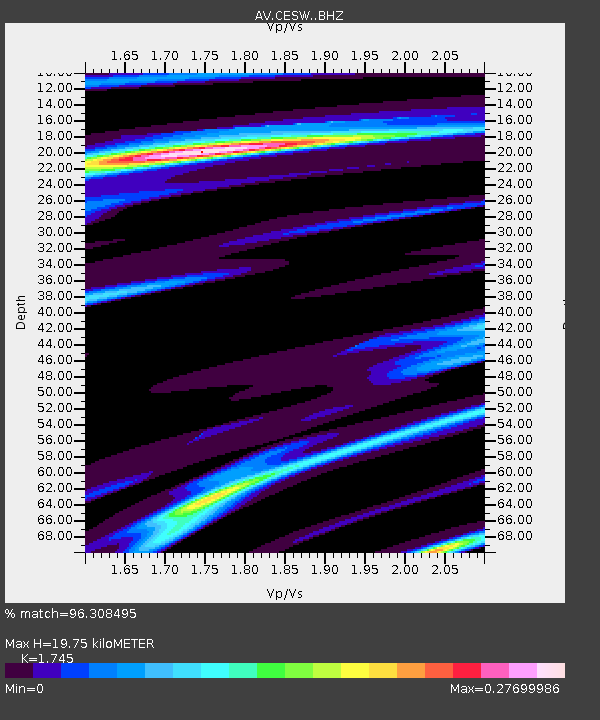
| Estimated Moho Depth: |
19.75 km |
| Estimated Crust Vp/Vs: |
1.75 |
| Assumed Crust Vp: |
6.183 km/s |
| Estimated Crust Vs: |
3.543 km/s |
| Estimated Crust Poisson's Ratio: |
0.26 |
|
| Radial Match: |
96.308495 % |
| Radial Bump: |
330 |
| Transverse Match: |
95.198326 % |
| Transverse Bump: |
176 |
| SOD ConfigId: |
29823551 |
| Insert Time: |
2023-01-03 10:35:24.125 +0000 |
| GWidth: |
2.5 |
| Max Bumps: |
400 |
| Tol: |
0.001 |
|

Signal To Noise
| Channel | StoN | STA | LTA |
| AV:CESW: :BHZ:20221220T10:41:23.120006Z | 4.0023994 | 7.850544E-5 | 1.9614596E-5 |
| AV:CESW: :BHN:20221220T10:41:23.120006Z | 3.992217 | 7.7751145E-5 | 1.947568E-5 |
| AV:CESW: :BHE:20221220T10:41:23.120006Z | 3.9228175 | 2.0772371E-5 | 5.2952687E-6 |
| Arrivals |
| Ps | 2.5 SECOND |
| PpPs | 8.2 SECOND |
| PsPs/PpSs | 11 SECOND |


