You are here: Home > Network List > XA95 - Missouri to Massachusetts Transect Stations List
> Station MM16 Lake Newton, Illinois > Earthquake Result Viewer
MM16 Lake Newton, Illinois - Earthquake Result Viewer
| Earthquake location: |
Near Coast Of Peru |
| Earthquake latitude/longitude: |
-10.5/-78.7 |
| Earthquake time(UTC): |
1995/09/23 (266) 22:31:58 GMT |
| Earthquake Depth: |
73 km |
| Earthquake Magnitude: |
5.9 MB, 6.5 UNKNOWN, 6.4 MW |
| Earthquake Catalog/Contributor: |
WHDF/NEIC |
|
| Network: |
XA Missouri to Massachusetts Transect |
| Station: |
MM16 Lake Newton, Illinois |
| Lat/Lon: |
38.92 N/88.30 W |
| Elevation: |
165 m |
|
| Distance: |
50.0 deg |
| Az: |
350.215 deg |
| Baz: |
167.629 deg |
| Ray Param: |
0.06812458 |
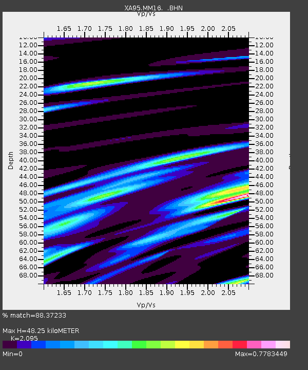
| Estimated Moho Depth: |
48.25 km |
| Estimated Crust Vp/Vs: |
2.10 |
| Assumed Crust Vp: |
6.444 km/s |
| Estimated Crust Vs: |
3.076 km/s |
| Estimated Crust Poisson's Ratio: |
0.35 |
|
| Radial Match: |
88.37233 % |
| Radial Bump: |
400 |
| Transverse Match: |
66.15685 % |
| Transverse Bump: |
400 |
| SOD ConfigId: |
6273 |
| Insert Time: |
2010-02-26 17:55:20.798 +0000 |
| GWidth: |
2.5 |
| Max Bumps: |
400 |
| Tol: |
0.001 |
|

Signal To Noise
| Channel | StoN | STA | LTA |
| XA:MM16: :BHN:19950923T22:40:14.737988Z | 1.4557023 | 1.4628422E-6 | 1.0049048E-6 |
| XA:MM16: :BHE:19950923T22:40:14.737988Z | 1.4136025 | 5.869219E-7 | 4.1519587E-7 |
| XA:MM16: :BHZ:19950923T22:40:14.737988Z | 7.138051 | 2.6243906E-6 | 3.6766207E-7 |
| Arrivals |
| Ps | 8.6 SECOND |
| PpPs | 22 SECOND |
| PsPs/PpSs | 31 SECOND |


