You are here: Home > Network List > US - United States National Seismic Network Stations List
> Station HAWA Hanford, Washington, USA > Earthquake Result Viewer
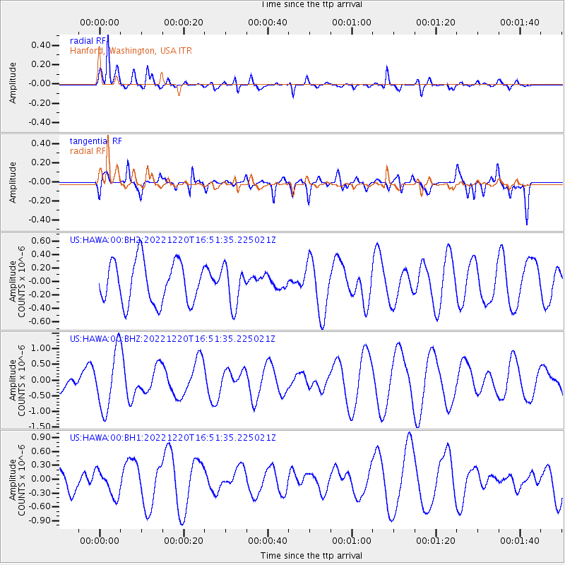
HAWA Hanford, Washington, USA - Earthquake Result Viewer
*The percent match for this event was below the threshold and hence no stack was calculated.
| Earthquake location: |
South Of Kermadec Islands |
| Earthquake latitude/longitude: |
-33.8/-179.7 |
| Earthquake time(UTC): |
2022/12/20 (354) 16:38:41 GMT |
| Earthquake Depth: |
39 km |
| Earthquake Magnitude: |
5.6 Mww |
| Earthquake Catalog/Contributor: |
NEIC PDE/us |
|
| Network: |
US United States National Seismic Network |
| Station: |
HAWA Hanford, Washington, USA |
| Lat/Lon: |
46.39 N/119.53 W |
| Elevation: |
364 m |
|
| Distance: |
96.5 deg |
| Az: |
37.199 deg |
| Baz: |
226.664 deg |
| Ray Param: |
$rayparam |
*The percent match for this event was below the threshold and hence was not used in the summary stack. |
|
| Radial Match: |
81.914635 % |
| Radial Bump: |
400 |
| Transverse Match: |
58.932037 % |
| Transverse Bump: |
400 |
| SOD ConfigId: |
29823551 |
| Insert Time: |
2023-01-03 16:53:24.938 +0000 |
| GWidth: |
2.5 |
| Max Bumps: |
400 |
| Tol: |
0.001 |
|
Signal To Noise
| Channel | StoN | STA | LTA |
| US:HAWA:00:BHZ:20221220T16:51:35.225021Z | 2.699676 | 9.4948473E-7 | 3.517032E-7 |
| US:HAWA:00:BH1:20221220T16:51:35.225021Z | 1.0206314 | 2.8522803E-7 | 2.794623E-7 |
| US:HAWA:00:BH2:20221220T16:51:35.225021Z | 0.95705354 | 2.9509877E-7 | 3.083409E-7 |
| Arrivals |
| Ps | |
| PpPs | |
| PsPs/PpSs | |


