You are here: Home > Network List > CI - Caltech Regional Seismic Network Stations List
> Station SWS Sam W. Stewart, Westmorland, CA, USA > Earthquake Result Viewer
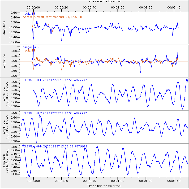
SWS Sam W. Stewart, Westmorland, CA, USA - Earthquake Result Viewer
*The percent match for this event was below the threshold and hence no stack was calculated.
| Earthquake location: |
Peru-Brazil Border Region |
| Earthquake latitude/longitude: |
-8.0/-74.5 |
| Earthquake time(UTC): |
2022/12/22 (356) 13:13:55 GMT |
| Earthquake Depth: |
157 km |
| Earthquake Magnitude: |
5.5 mww |
| Earthquake Catalog/Contributor: |
NEIC PDE/us |
|
| Network: |
CI Caltech Regional Seismic Network |
| Station: |
SWS Sam W. Stewart, Westmorland, CA, USA |
| Lat/Lon: |
32.94 N/115.80 W |
| Elevation: |
140 m |
|
| Distance: |
56.6 deg |
| Az: |
318.343 deg |
| Baz: |
128.486 deg |
| Ray Param: |
$rayparam |
*The percent match for this event was below the threshold and hence was not used in the summary stack. |
|
| Radial Match: |
57.816074 % |
| Radial Bump: |
400 |
| Transverse Match: |
73.23928 % |
| Transverse Bump: |
400 |
| SOD ConfigId: |
29823551 |
| Insert Time: |
2023-01-05 13:23:14.161 +0000 |
| GWidth: |
2.5 |
| Max Bumps: |
400 |
| Tol: |
0.001 |
|
Signal To Noise
| Channel | StoN | STA | LTA |
| CI:SWS: :HHZ:20221222T13:22:51.487993Z | 2.4957354 | 5.464116E-7 | 2.1893813E-7 |
| CI:SWS: :HHN:20221222T13:22:51.487993Z | 0.71429694 | 5.1525166E-7 | 7.21341E-7 |
| CI:SWS: :HHE:20221222T13:22:51.487993Z | 1.0008401 | 3.5852963E-7 | 3.5822868E-7 |
| Arrivals |
| Ps | |
| PpPs | |
| PsPs/PpSs | |


