You are here: Home > Network List > TX - Texas Seismological Network Stations List
> Station WTFS Witchita Falls > Earthquake Result Viewer
WTFS Witchita Falls - Earthquake Result Viewer
*The percent match for this event was below the threshold and hence no stack was calculated.
| Earthquake location: |
Peru-Brazil Border Region |
| Earthquake latitude/longitude: |
-8.0/-74.5 |
| Earthquake time(UTC): |
2022/12/22 (356) 13:13:55 GMT |
| Earthquake Depth: |
157 km |
| Earthquake Magnitude: |
5.5 mww |
| Earthquake Catalog/Contributor: |
NEIC PDE/us |
|
| Network: |
TX Texas Seismological Network |
| Station: |
WTFS Witchita Falls |
| Lat/Lon: |
33.77 N/98.46 W |
| Elevation: |
277 m |
|
| Distance: |
47.4 deg |
| Az: |
332.635 deg |
| Baz: |
146.878 deg |
| Ray Param: |
$rayparam |
*The percent match for this event was below the threshold and hence was not used in the summary stack. |
|
| Radial Match: |
44.985428 % |
| Radial Bump: |
400 |
| Transverse Match: |
63.79984 % |
| Transverse Bump: |
400 |
| SOD ConfigId: |
29823551 |
| Insert Time: |
2023-01-05 13:37:35.923 +0000 |
| GWidth: |
2.5 |
| Max Bumps: |
400 |
| Tol: |
0.001 |
|
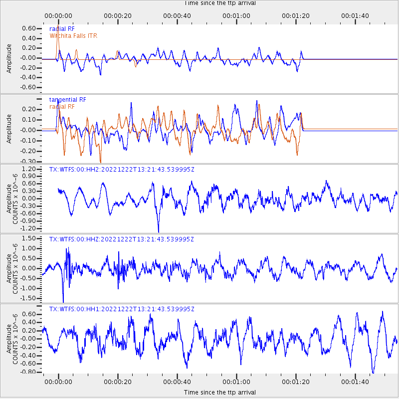
Signal To Noise
| Channel | StoN | STA | LTA |
| TX:WTFS:00:HHZ:20221222T13:21:43.539995Z | 2.993104 | 5.382688E-7 | 1.7983633E-7 |
| TX:WTFS:00:HH1:20221222T13:21:43.539995Z | 0.71016896 | 2.0069027E-7 | 2.8259507E-7 |
| TX:WTFS:00:HH2:20221222T13:21:43.539995Z | 1.5637039 | 4.8492984E-7 | 3.1011618E-7 |
| Arrivals |
| Ps | |
| PpPs | |
| PsPs/PpSs | |


