You are here: Home > Network List > US - United States National Seismic Network Stations List
> Station MNTX Cornudas Mountains, Texas, USA > Earthquake Result Viewer
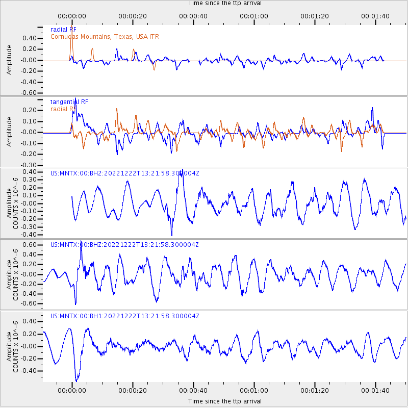
MNTX Cornudas Mountains, Texas, USA - Earthquake Result Viewer
*The percent match for this event was below the threshold and hence no stack was calculated.
| Earthquake location: |
Peru-Brazil Border Region |
| Earthquake latitude/longitude: |
-8.0/-74.5 |
| Earthquake time(UTC): |
2022/12/22 (356) 13:13:55 GMT |
| Earthquake Depth: |
157 km |
| Earthquake Magnitude: |
5.5 mww |
| Earthquake Catalog/Contributor: |
NEIC PDE/us |
|
| Network: |
US United States National Seismic Network |
| Station: |
MNTX Cornudas Mountains, Texas, USA |
| Lat/Lon: |
31.70 N/105.38 W |
| Elevation: |
405 m |
|
| Distance: |
49.3 deg |
| Az: |
324.771 deg |
| Baz: |
137.92 deg |
| Ray Param: |
$rayparam |
*The percent match for this event was below the threshold and hence was not used in the summary stack. |
|
| Radial Match: |
54.151756 % |
| Radial Bump: |
400 |
| Transverse Match: |
55.79371 % |
| Transverse Bump: |
400 |
| SOD ConfigId: |
29823551 |
| Insert Time: |
2023-01-05 13:38:46.101 +0000 |
| GWidth: |
2.5 |
| Max Bumps: |
400 |
| Tol: |
0.001 |
|
Signal To Noise
| Channel | StoN | STA | LTA |
| US:MNTX:00:BHZ:20221222T13:21:58.300004Z | 2.1659632 | 3.0087628E-7 | 1.3891108E-7 |
| US:MNTX:00:BH1:20221222T13:21:58.300004Z | 2.7387142 | 3.141895E-7 | 1.1472154E-7 |
| US:MNTX:00:BH2:20221222T13:21:58.300004Z | 1.2016233 | 1.5931974E-7 | 1.3258709E-7 |
| Arrivals |
| Ps | |
| PpPs | |
| PsPs/PpSs | |


