You are here: Home > Network List > US - United States National Seismic Network Stations List
> Station EGMT Eagleton, Montana, USA > Earthquake Result Viewer
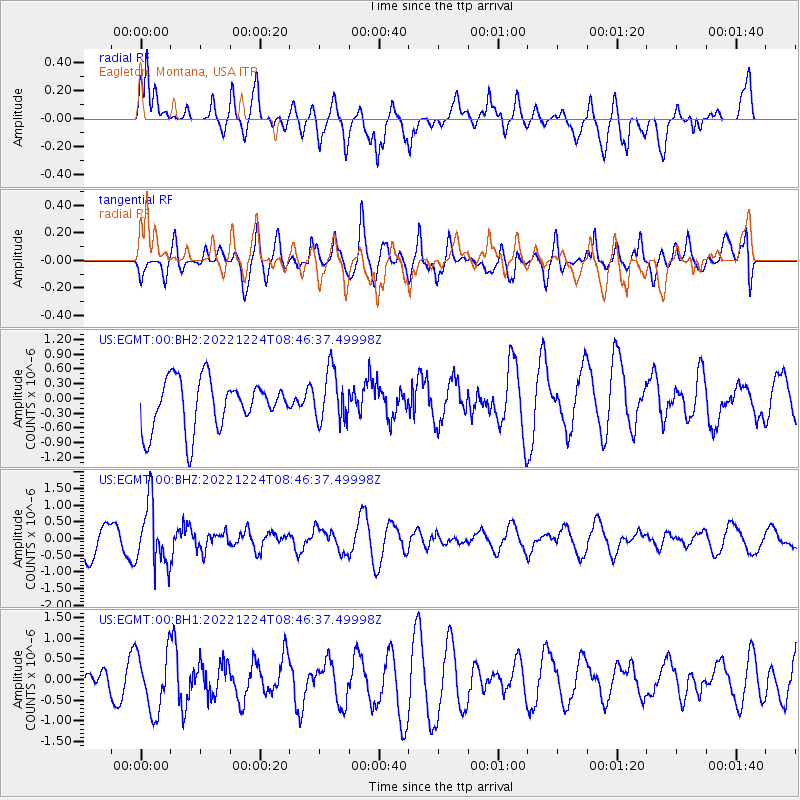
EGMT Eagleton, Montana, USA - Earthquake Result Viewer
*The percent match for this event was below the threshold and hence no stack was calculated.
| Earthquake location: |
Bonin Islands, Japan Region |
| Earthquake latitude/longitude: |
28.3/138.8 |
| Earthquake time(UTC): |
2022/12/24 (358) 08:35:41 GMT |
| Earthquake Depth: |
522 km |
| Earthquake Magnitude: |
5.5 mww |
| Earthquake Catalog/Contributor: |
NEIC PDE/us |
|
| Network: |
US United States National Seismic Network |
| Station: |
EGMT Eagleton, Montana, USA |
| Lat/Lon: |
48.02 N/109.75 W |
| Elevation: |
1055 m |
|
| Distance: |
82.4 deg |
| Az: |
39.079 deg |
| Baz: |
304.076 deg |
| Ray Param: |
$rayparam |
*The percent match for this event was below the threshold and hence was not used in the summary stack. |
|
| Radial Match: |
58.86144 % |
| Radial Bump: |
400 |
| Transverse Match: |
38.036076 % |
| Transverse Bump: |
400 |
| SOD ConfigId: |
29823551 |
| Insert Time: |
2023-01-07 08:58:53.769 +0000 |
| GWidth: |
2.5 |
| Max Bumps: |
400 |
| Tol: |
0.001 |
|
Signal To Noise
| Channel | StoN | STA | LTA |
| US:EGMT:00:BHZ:20221224T08:46:37.49998Z | 1.598217 | 9.2410704E-7 | 5.7821126E-7 |
| US:EGMT:00:BH1:20221224T08:46:37.49998Z | 1.5936944 | 7.3393494E-7 | 4.6052423E-7 |
| US:EGMT:00:BH2:20221224T08:46:37.49998Z | 1.0530492 | 5.261513E-7 | 4.996455E-7 |
| Arrivals |
| Ps | |
| PpPs | |
| PsPs/PpSs | |


