You are here: Home > Network List > CI - Caltech Regional Seismic Network Stations List
> Station GLA Glamis, Glamis, CA, USA > Earthquake Result Viewer
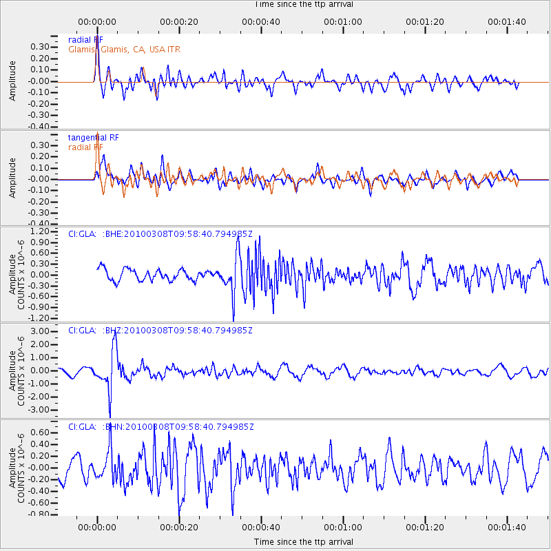
GLA Glamis, Glamis, CA, USA - Earthquake Result Viewer
*The percent match for this event was below the threshold and hence no stack was calculated.
| Earthquake location: |
Mariana Islands |
| Earthquake latitude/longitude: |
19.3/144.7 |
| Earthquake time(UTC): |
2010/03/08 (067) 09:47:11 GMT |
| Earthquake Depth: |
457 km |
| Earthquake Magnitude: |
6.0 MB, 6.1 MW, 6.1 MW |
| Earthquake Catalog/Contributor: |
WHDF/NEIC |
|
| Network: |
CI Caltech Regional Seismic Network |
| Station: |
GLA Glamis, Glamis, CA, USA |
| Lat/Lon: |
33.05 N/114.83 W |
| Elevation: |
610 m |
|
| Distance: |
88.0 deg |
| Az: |
55.728 deg |
| Baz: |
291.693 deg |
| Ray Param: |
$rayparam |
*The percent match for this event was below the threshold and hence was not used in the summary stack. |
|
| Radial Match: |
73.906334 % |
| Radial Bump: |
400 |
| Transverse Match: |
74.30211 % |
| Transverse Bump: |
400 |
| SOD ConfigId: |
299721 |
| Insert Time: |
2010-04-26 19:27:17.388 +0000 |
| GWidth: |
2.5 |
| Max Bumps: |
400 |
| Tol: |
0.001 |
|
Signal To Noise
| Channel | StoN | STA | LTA |
| CI:GLA: :BHZ:20100308T09:58:40.794985Z | 7.8109417 | 1.5566807E-6 | 1.9929487E-7 |
| CI:GLA: :BHN:20100308T09:58:40.794985Z | 1.9279741 | 2.5933628E-7 | 1.3451232E-7 |
| CI:GLA: :BHE:20100308T09:58:40.794985Z | 3.2673464 | 5.116545E-7 | 1.5659633E-7 |
| Arrivals |
| Ps | |
| PpPs | |
| PsPs/PpSs | |


