You are here: Home > Network List > XA95 - Missouri to Massachusetts Transect Stations List
> Station MM16 Lake Newton, Illinois > Earthquake Result Viewer
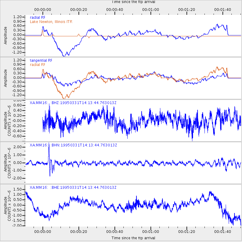
MM16 Lake Newton, Illinois - Earthquake Result Viewer
*The percent match for this event was below the threshold and hence no stack was calculated.
| Earthquake location: |
Sea Of Japan |
| Earthquake latitude/longitude: |
38.2/135.1 |
| Earthquake time(UTC): |
1995/03/31 (090) 14:01:40 GMT |
| Earthquake Depth: |
365 km |
| Earthquake Magnitude: |
6.0 MB, 6.2 UNKNOWN, 6.3 MW |
| Earthquake Catalog/Contributor: |
WHDF/NEIC |
|
| Network: |
XA Missouri to Massachusetts Transect |
| Station: |
MM16 Lake Newton, Illinois |
| Lat/Lon: |
38.92 N/88.30 W |
| Elevation: |
165 m |
|
| Distance: |
93.6 deg |
| Az: |
32.455 deg |
| Baz: |
327.154 deg |
| Ray Param: |
$rayparam |
*The percent match for this event was below the threshold and hence was not used in the summary stack. |
|
| Radial Match: |
25.7249 % |
| Radial Bump: |
400 |
| Transverse Match: |
29.043344 % |
| Transverse Bump: |
400 |
| SOD ConfigId: |
4480 |
| Insert Time: |
2010-02-26 17:55:36.293 +0000 |
| GWidth: |
2.5 |
| Max Bumps: |
400 |
| Tol: |
0.001 |
|
Signal To Noise
| Channel | StoN | STA | LTA |
| XA:MM16: :BHN:19950331T14:13:44.763013Z | 4.0776258 | 7.0866156E-7 | 1.737927E-7 |
| XA:MM16: :BHE:19950331T14:13:44.763013Z | 1.2594588 | 1.0246597E-6 | 8.1357143E-7 |
| XA:MM16: :BHZ:19950331T14:13:44.763013Z | 1.5405589 | 3.193086E-7 | 2.0726803E-7 |
| Arrivals |
| Ps | |
| PpPs | |
| PsPs/PpSs | |


