You are here: Home > Network List > XA95 - Missouri to Massachusetts Transect Stations List
> Station MM16 Lake Newton, Illinois > Earthquake Result Viewer
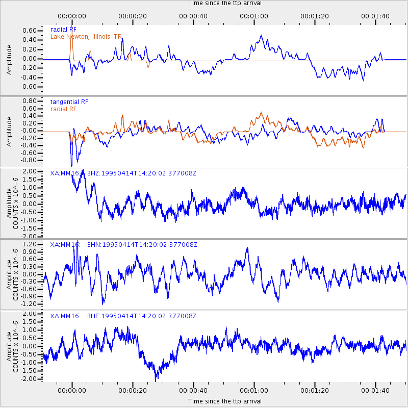
MM16 Lake Newton, Illinois - Earthquake Result Viewer
*The percent match for this event was below the threshold and hence no stack was calculated.
| Earthquake location: |
Ecuador |
| Earthquake latitude/longitude: |
-1.9/-77.5 |
| Earthquake time(UTC): |
1995/04/14 (104) 14:12:59 GMT |
| Earthquake Depth: |
165 km |
| Earthquake Magnitude: |
5.5 MB, 5.4 UNKNOWN |
| Earthquake Catalog/Contributor: |
WHDF/NEIC |
|
| Network: |
XA Missouri to Massachusetts Transect |
| Station: |
MM16 Lake Newton, Illinois |
| Lat/Lon: |
38.92 N/88.30 W |
| Elevation: |
165 m |
|
| Distance: |
41.8 deg |
| Az: |
347.367 deg |
| Baz: |
163.727 deg |
| Ray Param: |
$rayparam |
*The percent match for this event was below the threshold and hence was not used in the summary stack. |
|
| Radial Match: |
51.981808 % |
| Radial Bump: |
400 |
| Transverse Match: |
56.15413 % |
| Transverse Bump: |
400 |
| SOD ConfigId: |
4480 |
| Insert Time: |
2010-02-26 17:55:37.400 +0000 |
| GWidth: |
2.5 |
| Max Bumps: |
400 |
| Tol: |
0.001 |
|
Signal To Noise
| Channel | StoN | STA | LTA |
| XA:MM16: :BHN:19950414T14:20:02.377008Z | 1.2570916 | 5.9846735E-7 | 4.7607296E-7 |
| XA:MM16: :BHE:19950414T14:20:02.377008Z | 0.5959147 | 5.1664546E-7 | 8.669789E-7 |
| XA:MM16: :BHZ:19950414T14:20:02.377008Z | 1.1571856 | 8.664704E-7 | 7.487739E-7 |
| Arrivals |
| Ps | |
| PpPs | |
| PsPs/PpSs | |


