You are here: Home > Network List > US - United States National Seismic Network Stations List
> Station SDCO Great Sand Dunes National Park, Colorado, USA > Earthquake Result Viewer
SDCO Great Sand Dunes National Park, Colorado, USA - Earthquake Result Viewer
| Earthquake location: |
Komandorskiye Ostrova Region |
| Earthquake latitude/longitude: |
55.4/166.5 |
| Earthquake time(UTC): |
2018/01/25 (025) 02:10:33 GMT |
| Earthquake Depth: |
8.8 km |
| Earthquake Magnitude: |
6.2 Mww |
| Earthquake Catalog/Contributor: |
NEIC PDE/us |
|
| Network: |
US United States National Seismic Network |
| Station: |
SDCO Great Sand Dunes National Park, Colorado, USA |
| Lat/Lon: |
37.75 N/105.50 W |
| Elevation: |
2569 m |
|
| Distance: |
58.9 deg |
| Az: |
67.682 deg |
| Baz: |
318.269 deg |
| Ray Param: |
0.06253627 |
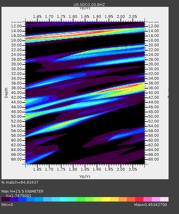
| Estimated Moho Depth: |
15.5 km |
| Estimated Crust Vp/Vs: |
1.75 |
| Assumed Crust Vp: |
6.316 km/s |
| Estimated Crust Vs: |
3.614 km/s |
| Estimated Crust Poisson's Ratio: |
0.26 |
|
| Radial Match: |
94.83437 % |
| Radial Bump: |
295 |
| Transverse Match: |
89.12954 % |
| Transverse Bump: |
400 |
| SOD ConfigId: |
2973751 |
| Insert Time: |
2018-10-09 06:34:04.870 +0000 |
| GWidth: |
2.5 |
| Max Bumps: |
400 |
| Tol: |
0.001 |
|

Signal To Noise
| Channel | StoN | STA | LTA |
| US:SDCO:00:BHZ:20180125T02:20:02.450015Z | 0.8518883 | 1.7310282E-7 | 2.0319898E-7 |
| US:SDCO:00:BH1:20180125T02:20:02.450015Z | 2.085748 | 1.8633189E-7 | 8.9335764E-8 |
| US:SDCO:00:BH2:20180125T02:20:02.450015Z | 0.8270745 | 1.839614E-7 | 2.224242E-7 |
| Arrivals |
| Ps | 1.9 SECOND |
| PpPs | 6.4 SECOND |
| PsPs/PpSs | 8.4 SECOND |


