You are here: Home > Network List > CI - Caltech Regional Seismic Network Stations List
> Station FMP Fort MacArthur Park, Pt. Fermin San Pedro, CA, USA > Earthquake Result Viewer
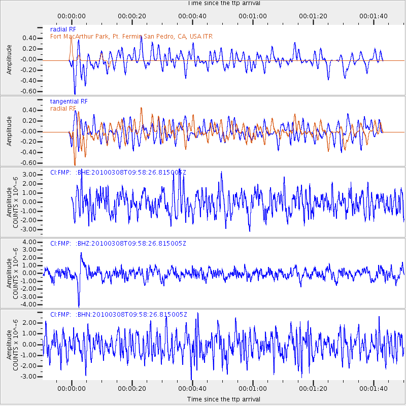
FMP Fort MacArthur Park, Pt. Fermin San Pedro, CA, USA - Earthquake Result Viewer
*The percent match for this event was below the threshold and hence no stack was calculated.
| Earthquake location: |
Mariana Islands |
| Earthquake latitude/longitude: |
19.3/144.7 |
| Earthquake time(UTC): |
2010/03/08 (067) 09:47:11 GMT |
| Earthquake Depth: |
457 km |
| Earthquake Magnitude: |
6.0 MB, 6.1 MW, 6.1 MW |
| Earthquake Catalog/Contributor: |
WHDF/NEIC |
|
| Network: |
CI Caltech Regional Seismic Network |
| Station: |
FMP Fort MacArthur Park, Pt. Fermin San Pedro, CA, USA |
| Lat/Lon: |
33.71 N/118.29 W |
| Elevation: |
89 m |
|
| Distance: |
85.1 deg |
| Az: |
56.14 deg |
| Baz: |
289.819 deg |
| Ray Param: |
$rayparam |
*The percent match for this event was below the threshold and hence was not used in the summary stack. |
|
| Radial Match: |
52.436317 % |
| Radial Bump: |
400 |
| Transverse Match: |
58.31475 % |
| Transverse Bump: |
400 |
| SOD ConfigId: |
299721 |
| Insert Time: |
2010-04-26 19:30:34.625 +0000 |
| GWidth: |
2.5 |
| Max Bumps: |
400 |
| Tol: |
0.001 |
|
Signal To Noise
| Channel | StoN | STA | LTA |
| CI:FMP: :BHZ:20100308T09:58:26.815005Z | 3.3880303 | 1.4975561E-6 | 4.420138E-7 |
| CI:FMP: :BHN:20100308T09:58:26.815005Z | 1.0090921 | 9.378697E-7 | 9.294194E-7 |
| CI:FMP: :BHE:20100308T09:58:26.815005Z | 1.1717702 | 1.3166215E-6 | 1.1236175E-6 |
| Arrivals |
| Ps | |
| PpPs | |
| PsPs/PpSs | |


