You are here: Home > Network List > IW - Intermountain West Stations List
> Station DLMT Dillon, Montana, USA > Earthquake Result Viewer
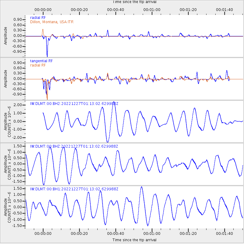
DLMT Dillon, Montana, USA - Earthquake Result Viewer
*The percent match for this event was below the threshold and hence no stack was calculated.
| Earthquake location: |
Tonga Islands Region |
| Earthquake latitude/longitude: |
-22.0/-174.5 |
| Earthquake time(UTC): |
2022/12/27 (361) 01:00:46 GMT |
| Earthquake Depth: |
10 km |
| Earthquake Magnitude: |
5.5 Mww |
| Earthquake Catalog/Contributor: |
NEIC PDE/us |
|
| Network: |
IW Intermountain West |
| Station: |
DLMT Dillon, Montana, USA |
| Lat/Lon: |
45.36 N/112.60 W |
| Elevation: |
1569 m |
|
| Distance: |
87.5 deg |
| Az: |
38.494 deg |
| Baz: |
235.01 deg |
| Ray Param: |
$rayparam |
*The percent match for this event was below the threshold and hence was not used in the summary stack. |
|
| Radial Match: |
81.90161 % |
| Radial Bump: |
296 |
| Transverse Match: |
80.43672 % |
| Transverse Bump: |
400 |
| SOD ConfigId: |
29823551 |
| Insert Time: |
2023-01-10 01:13:21.864 +0000 |
| GWidth: |
2.5 |
| Max Bumps: |
400 |
| Tol: |
0.001 |
|
Signal To Noise
| Channel | StoN | STA | LTA |
| IW:DLMT:00:BHZ:20221227T01:13:02.629988Z | 2.0113418 | 1.1865686E-6 | 5.899388E-7 |
| IW:DLMT:00:BH1:20221227T01:13:02.629988Z | 0.9135522 | 4.0061056E-7 | 4.3851963E-7 |
| IW:DLMT:00:BH2:20221227T01:13:02.629988Z | 1.7310444 | 1.1363991E-6 | 6.564818E-7 |
| Arrivals |
| Ps | |
| PpPs | |
| PsPs/PpSs | |


