You are here: Home > Network List > UU - University of Utah Regional Network Stations List
> Station KNB Kanab, UT, USA > Earthquake Result Viewer
KNB Kanab, UT, USA - Earthquake Result Viewer
| Earthquake location: |
Komandorskiye Ostrova Region |
| Earthquake latitude/longitude: |
55.4/166.5 |
| Earthquake time(UTC): |
2018/01/25 (025) 02:10:33 GMT |
| Earthquake Depth: |
8.8 km |
| Earthquake Magnitude: |
6.2 Mww |
| Earthquake Catalog/Contributor: |
NEIC PDE/us |
|
| Network: |
UU University of Utah Regional Network |
| Station: |
KNB Kanab, UT, USA |
| Lat/Lon: |
37.02 N/112.82 W |
| Elevation: |
1715 m |
|
| Distance: |
55.5 deg |
| Az: |
73.386 deg |
| Baz: |
316.931 deg |
| Ray Param: |
0.06474462 |
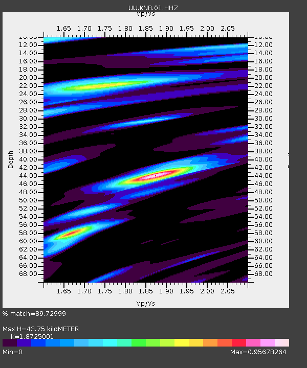
| Estimated Moho Depth: |
43.75 km |
| Estimated Crust Vp/Vs: |
1.87 |
| Assumed Crust Vp: |
6.194 km/s |
| Estimated Crust Vs: |
3.308 km/s |
| Estimated Crust Poisson's Ratio: |
0.30 |
|
| Radial Match: |
89.72999 % |
| Radial Bump: |
299 |
| Transverse Match: |
86.064125 % |
| Transverse Bump: |
352 |
| SOD ConfigId: |
2973751 |
| Insert Time: |
2018-10-09 06:34:22.368 +0000 |
| GWidth: |
2.5 |
| Max Bumps: |
400 |
| Tol: |
0.001 |
|
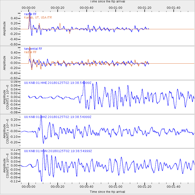
Signal To Noise
| Channel | StoN | STA | LTA |
| UU:KNB:01:HHZ:20180125T02:19:38.54999Z | 0.8746497 | 5.187684E-9 | 5.931156E-9 |
| UU:KNB:01:HHN:20180125T02:19:38.54999Z | 1.5396783 | 8.264508E-9 | 5.367685E-9 |
| UU:KNB:01:HHE:20180125T02:19:38.54999Z | 1.4302534 | 5.9011476E-9 | 4.125946E-9 |
| Arrivals |
| Ps | 6.4 SECOND |
| PpPs | 19 SECOND |
| PsPs/PpSs | 26 SECOND |


