You are here: Home > Network List > US - United States National Seismic Network Stations List
> Station EGMT Eagleton, Montana, USA > Earthquake Result Viewer
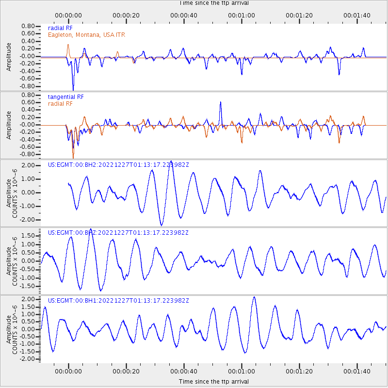
EGMT Eagleton, Montana, USA - Earthquake Result Viewer
*The percent match for this event was below the threshold and hence no stack was calculated.
| Earthquake location: |
Tonga Islands Region |
| Earthquake latitude/longitude: |
-22.0/-174.5 |
| Earthquake time(UTC): |
2022/12/27 (361) 01:00:46 GMT |
| Earthquake Depth: |
10 km |
| Earthquake Magnitude: |
5.5 Mww |
| Earthquake Catalog/Contributor: |
NEIC PDE/us |
|
| Network: |
US United States National Seismic Network |
| Station: |
EGMT Eagleton, Montana, USA |
| Lat/Lon: |
48.02 N/109.75 W |
| Elevation: |
1055 m |
|
| Distance: |
90.6 deg |
| Az: |
37.379 deg |
| Baz: |
237.054 deg |
| Ray Param: |
$rayparam |
*The percent match for this event was below the threshold and hence was not used in the summary stack. |
|
| Radial Match: |
80.06787 % |
| Radial Bump: |
400 |
| Transverse Match: |
64.55212 % |
| Transverse Bump: |
400 |
| SOD ConfigId: |
29823551 |
| Insert Time: |
2023-01-10 01:22:03.974 +0000 |
| GWidth: |
2.5 |
| Max Bumps: |
400 |
| Tol: |
0.001 |
|
Signal To Noise
| Channel | StoN | STA | LTA |
| US:EGMT:00:BHZ:20221227T01:13:17.223982Z | 3.3587701 | 1.1493756E-6 | 3.4220133E-7 |
| US:EGMT:00:BH1:20221227T01:13:17.223982Z | 0.6642287 | 4.1539124E-7 | 6.253739E-7 |
| US:EGMT:00:BH2:20221227T01:13:17.223982Z | 2.662472 | 1.4467854E-6 | 5.433993E-7 |
| Arrivals |
| Ps | |
| PpPs | |
| PsPs/PpSs | |


