You are here: Home > Network List > XA95 - Missouri to Massachusetts Transect Stations List
> Station MM16 Lake Newton, Illinois > Earthquake Result Viewer
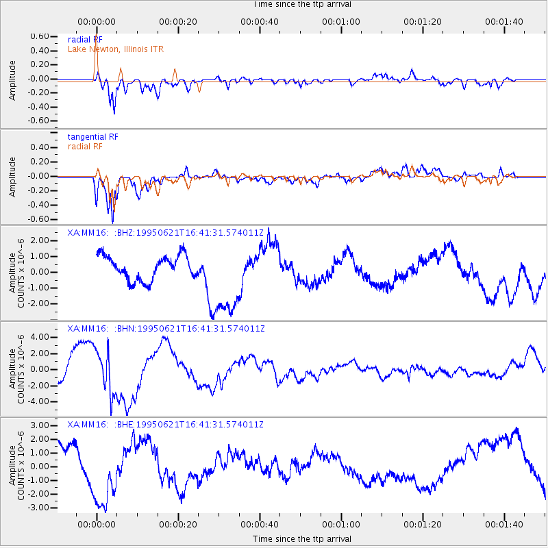
MM16 Lake Newton, Illinois - Earthquake Result Viewer
*The percent match for this event was below the threshold and hence no stack was calculated.
| Earthquake location: |
Near Coast Of Peru |
| Earthquake latitude/longitude: |
-11.5/-77.6 |
| Earthquake time(UTC): |
1995/06/21 (172) 16:33:05 GMT |
| Earthquake Depth: |
70 km |
| Earthquake Magnitude: |
5.5 MB |
| Earthquake Catalog/Contributor: |
WHDF/NEIC |
|
| Network: |
XA Missouri to Massachusetts Transect |
| Station: |
MM16 Lake Newton, Illinois |
| Lat/Lon: |
38.92 N/88.30 W |
| Elevation: |
165 m |
|
| Distance: |
51.2 deg |
| Az: |
349.249 deg |
| Baz: |
166.446 deg |
| Ray Param: |
$rayparam |
*The percent match for this event was below the threshold and hence was not used in the summary stack. |
|
| Radial Match: |
68.698524 % |
| Radial Bump: |
400 |
| Transverse Match: |
75.903694 % |
| Transverse Bump: |
400 |
| SOD ConfigId: |
4480 |
| Insert Time: |
2010-02-26 17:55:39.771 +0000 |
| GWidth: |
2.5 |
| Max Bumps: |
400 |
| Tol: |
0.001 |
|
Signal To Noise
| Channel | StoN | STA | LTA |
| XA:MM16: :BHN:19950621T16:41:31.574011Z | 1.8743535 | 2.7549263E-6 | 1.4698007E-6 |
| XA:MM16: :BHE:19950621T16:41:31.574011Z | 2.0738978 | 2.6947298E-6 | 1.2993552E-6 |
| XA:MM16: :BHZ:19950621T16:41:31.574011Z | 3.3500288 | 2.5025936E-6 | 7.4703644E-7 |
| Arrivals |
| Ps | |
| PpPs | |
| PsPs/PpSs | |


