You are here: Home > Network List > AV - Alaska Volcano Observatory Stations List
> Station TAFP Falls Point, Tanaga Volcano, Alaska > Earthquake Result Viewer
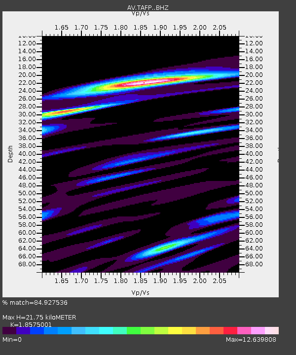
TAFP Falls Point, Tanaga Volcano, Alaska - Earthquake Result Viewer
| Earthquake location: |
Kyrgyzstan-Xinjiang Border Reg. |
| Earthquake latitude/longitude: |
41.8/79.5 |
| Earthquake time(UTC): |
2022/12/28 (362) 17:16:36 GMT |
| Earthquake Depth: |
10 km |
| Earthquake Magnitude: |
5.6 mb |
| Earthquake Catalog/Contributor: |
NEIC PDE/us |
|
| Network: |
AV Alaska Volcano Observatory |
| Station: |
TAFP Falls Point, Tanaga Volcano, Alaska |
| Lat/Lon: |
51.90 N/177.99 W |
| Elevation: |
440 m |
|
| Distance: |
65.1 deg |
| Az: |
41.84 deg |
| Baz: |
306.403 deg |
| Ray Param: |
0.05850601 |
| Estimated Moho Depth: |
21.75 km |
| Estimated Crust Vp/Vs: |
1.86 |
| Assumed Crust Vp: |
5.88 km/s |
| Estimated Crust Vs: |
3.166 km/s |
| Estimated Crust Poisson's Ratio: |
0.30 |
|
| Radial Match: |
84.927536 % |
| Radial Bump: |
400 |
| Transverse Match: |
83.69985 % |
| Transverse Bump: |
400 |
| SOD ConfigId: |
29823551 |
| Insert Time: |
2023-01-11 17:21:55.836 +0000 |
| GWidth: |
2.5 |
| Max Bumps: |
400 |
| Tol: |
0.001 |
|

Signal To Noise
| Channel | StoN | STA | LTA |
| AV:TAFP: :BHZ:20221228T17:26:45.71999Z | 0.57603675 | 2.6989997E-7 | 4.6854643E-7 |
| AV:TAFP: :BHN:20221228T17:26:45.71999Z | 1.2794081 | 1.8589203E-6 | 1.4529535E-6 |
| AV:TAFP: :BHE:20221228T17:26:45.71999Z | 2.116889 | 2.4027497E-6 | 1.1350382E-6 |
| Arrivals |
| Ps | 3.3 SECOND |
| PpPs | 10 SECOND |
| PsPs/PpSs | 14 SECOND |


