You are here: Home > Network List > IW - Intermountain West Stations List
> Station PLID Pearl Lake, Idaho, USA > Earthquake Result Viewer
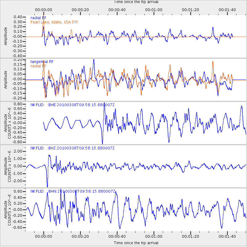
PLID Pearl Lake, Idaho, USA - Earthquake Result Viewer
*The percent match for this event was below the threshold and hence no stack was calculated.
| Earthquake location: |
Mariana Islands |
| Earthquake latitude/longitude: |
19.3/144.7 |
| Earthquake time(UTC): |
2010/03/08 (067) 09:47:11 GMT |
| Earthquake Depth: |
457 km |
| Earthquake Magnitude: |
6.0 MB, 6.1 MW, 6.1 MW |
| Earthquake Catalog/Contributor: |
WHDF/NEIC |
|
| Network: |
IW Intermountain West |
| Station: |
PLID Pearl Lake, Idaho, USA |
| Lat/Lon: |
45.09 N/116.00 W |
| Elevation: |
2164 m |
|
| Distance: |
82.9 deg |
| Az: |
44.794 deg |
| Baz: |
290.08 deg |
| Ray Param: |
$rayparam |
*The percent match for this event was below the threshold and hence was not used in the summary stack. |
|
| Radial Match: |
58.441677 % |
| Radial Bump: |
400 |
| Transverse Match: |
50.407654 % |
| Transverse Bump: |
400 |
| SOD ConfigId: |
299721 |
| Insert Time: |
2010-04-26 19:35:18.512 +0000 |
| GWidth: |
2.5 |
| Max Bumps: |
400 |
| Tol: |
0.001 |
|
Signal To Noise
| Channel | StoN | STA | LTA |
| IW:PLID: :BHZ:20100308T09:58:15.880007Z | 4.4860044 | 1.0303881E-6 | 2.296895E-7 |
| IW:PLID: :BHN:20100308T09:58:15.880007Z | 2.4802723 | 2.703539E-7 | 1.0900169E-7 |
| IW:PLID: :BHE:20100308T09:58:15.880007Z | 2.5784862 | 3.8845636E-7 | 1.5065287E-7 |
| Arrivals |
| Ps | |
| PpPs | |
| PsPs/PpSs | |


