You are here: Home > Network List > XA95 - Missouri to Massachusetts Transect Stations List
> Station MM16 Lake Newton, Illinois > Earthquake Result Viewer
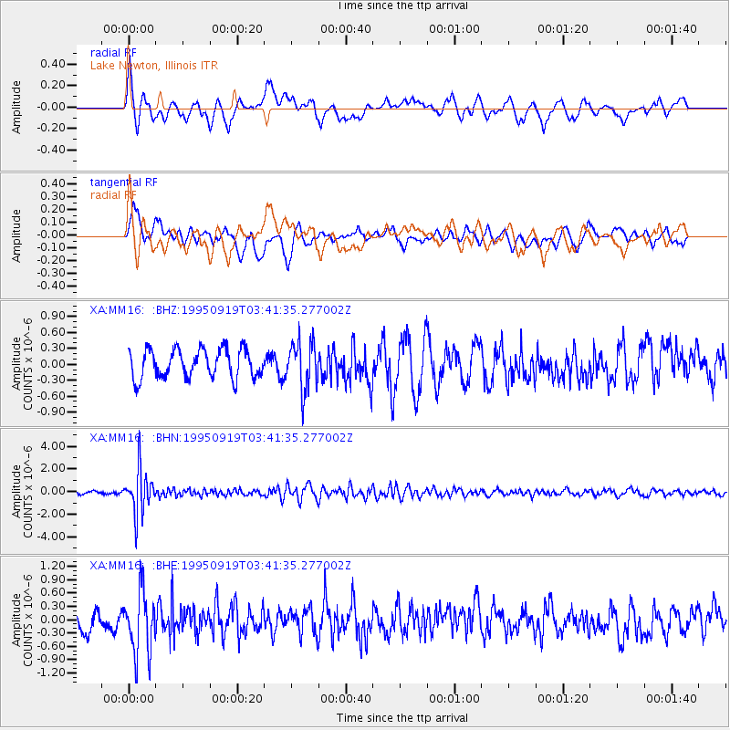
MM16 Lake Newton, Illinois - Earthquake Result Viewer
*The percent match for this event was below the threshold and hence no stack was calculated.
| Earthquake location: |
Chile-Bolivia Border Region |
| Earthquake latitude/longitude: |
-21.2/-68.7 |
| Earthquake time(UTC): |
1995/09/19 (262) 03:31:53 GMT |
| Earthquake Depth: |
110 km |
| Earthquake Magnitude: |
5.7 MB, 5.7 UNKNOWN, 5.6 MW |
| Earthquake Catalog/Contributor: |
WHDF/NEIC |
|
| Network: |
XA Missouri to Massachusetts Transect |
| Station: |
MM16 Lake Newton, Illinois |
| Lat/Lon: |
38.92 N/88.30 W |
| Elevation: |
165 m |
|
| Distance: |
62.6 deg |
| Az: |
342.886 deg |
| Baz: |
159.393 deg |
| Ray Param: |
$rayparam |
*The percent match for this event was below the threshold and hence was not used in the summary stack. |
|
| Radial Match: |
66.11379 % |
| Radial Bump: |
400 |
| Transverse Match: |
55.149376 % |
| Transverse Bump: |
400 |
| SOD ConfigId: |
4480 |
| Insert Time: |
2010-02-26 17:55:46.636 +0000 |
| GWidth: |
2.5 |
| Max Bumps: |
400 |
| Tol: |
0.001 |
|
Signal To Noise
| Channel | StoN | STA | LTA |
| XA:MM16: :BHN:19950919T03:41:35.277002Z | 11.768637 | 1.926653E-6 | 1.6371082E-7 |
| XA:MM16: :BHE:19950919T03:41:35.277002Z | 2.4454885 | 7.237181E-7 | 2.9594008E-7 |
| XA:MM16: :BHZ:19950919T03:41:35.277002Z | 1.6693473 | 4.5103047E-7 | 2.701837E-7 |
| Arrivals |
| Ps | |
| PpPs | |
| PsPs/PpSs | |


