You are here: Home > Network List > TA - USArray Transportable Network (new EarthScope stations) Stations List
> Station V26A Tequesquite Ranch, Mosquero, NM, USA > Earthquake Result Viewer
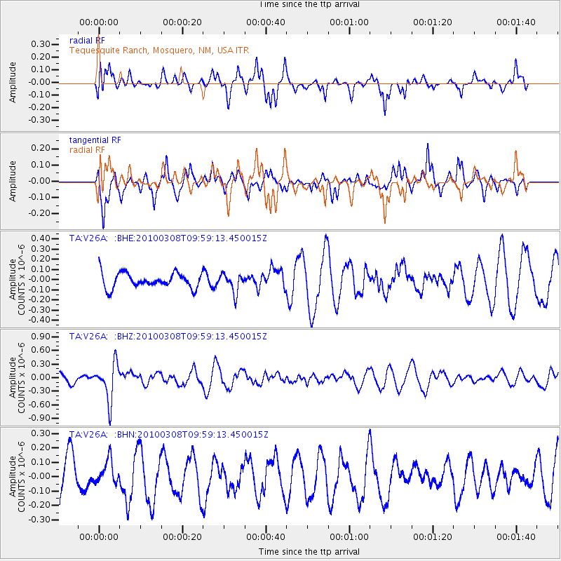
V26A Tequesquite Ranch, Mosquero, NM, USA - Earthquake Result Viewer
*The percent match for this event was below the threshold and hence no stack was calculated.
| Earthquake location: |
Mariana Islands |
| Earthquake latitude/longitude: |
19.3/144.7 |
| Earthquake time(UTC): |
2010/03/08 (067) 09:47:11 GMT |
| Earthquake Depth: |
457 km |
| Earthquake Magnitude: |
6.0 MB, 6.1 MW, 6.1 MW |
| Earthquake Catalog/Contributor: |
WHDF/NEIC |
|
| Network: |
TA USArray Transportable Network (new EarthScope stations) |
| Station: |
V26A Tequesquite Ranch, Mosquero, NM, USA |
| Lat/Lon: |
35.80 N/103.79 W |
| Elevation: |
1362 m |
|
| Distance: |
95.2 deg |
| Az: |
49.414 deg |
| Baz: |
298.096 deg |
| Ray Param: |
$rayparam |
*The percent match for this event was below the threshold and hence was not used in the summary stack. |
|
| Radial Match: |
51.590717 % |
| Radial Bump: |
341 |
| Transverse Match: |
68.74146 % |
| Transverse Bump: |
349 |
| SOD ConfigId: |
299721 |
| Insert Time: |
2010-04-26 19:41:46.078 +0000 |
| GWidth: |
2.5 |
| Max Bumps: |
400 |
| Tol: |
0.001 |
|
Signal To Noise
| Channel | StoN | STA | LTA |
| TA:V26A: :BHZ:20100308T09:59:13.450015Z | 3.9067008 | 4.2155304E-7 | 1.07905116E-7 |
| TA:V26A: :BHN:20100308T09:59:13.450015Z | 0.5763088 | 8.725261E-8 | 1.5139906E-7 |
| TA:V26A: :BHE:20100308T09:59:13.450015Z | 1.2765487 | 9.4393535E-8 | 7.394432E-8 |
| Arrivals |
| Ps | |
| PpPs | |
| PsPs/PpSs | |


