You are here: Home > Network List > TA - USArray Transportable Network (new EarthScope stations) Stations List
> Station M23A Laramie, WY, USA > Earthquake Result Viewer
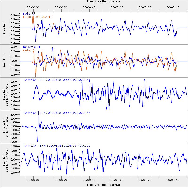
M23A Laramie, WY, USA - Earthquake Result Viewer
*The percent match for this event was below the threshold and hence no stack was calculated.
| Earthquake location: |
Mariana Islands |
| Earthquake latitude/longitude: |
19.3/144.7 |
| Earthquake time(UTC): |
2010/03/08 (067) 09:47:11 GMT |
| Earthquake Depth: |
457 km |
| Earthquake Magnitude: |
6.0 MB, 6.1 MW, 6.1 MW |
| Earthquake Catalog/Contributor: |
WHDF/NEIC |
|
| Network: |
TA USArray Transportable Network (new EarthScope stations) |
| Station: |
M23A Laramie, WY, USA |
| Lat/Lon: |
41.47 N/105.72 W |
| Elevation: |
2166 m |
|
| Distance: |
91.2 deg |
| Az: |
45.094 deg |
| Baz: |
297.13 deg |
| Ray Param: |
$rayparam |
*The percent match for this event was below the threshold and hence was not used in the summary stack. |
|
| Radial Match: |
73.51549 % |
| Radial Bump: |
400 |
| Transverse Match: |
74.58281 % |
| Transverse Bump: |
376 |
| SOD ConfigId: |
299721 |
| Insert Time: |
2010-04-26 19:45:00.382 +0000 |
| GWidth: |
2.5 |
| Max Bumps: |
400 |
| Tol: |
0.001 |
|
Signal To Noise
| Channel | StoN | STA | LTA |
| TA:M23A: :BHZ:20100308T09:58:55.400027Z | 15.22071 | 1.5629763E-6 | 1.0268748E-7 |
| TA:M23A: :BHN:20100308T09:58:55.400027Z | 1.3035752 | 2.727003E-7 | 2.0919417E-7 |
| TA:M23A: :BHE:20100308T09:58:55.400027Z | 2.0583305 | 4.6908667E-7 | 2.2789666E-7 |
| Arrivals |
| Ps | |
| PpPs | |
| PsPs/PpSs | |


