You are here: Home > Network List > TA - USArray Transportable Network (new EarthScope stations) Stations List
> Station I20A Worland, WY, USA > Earthquake Result Viewer
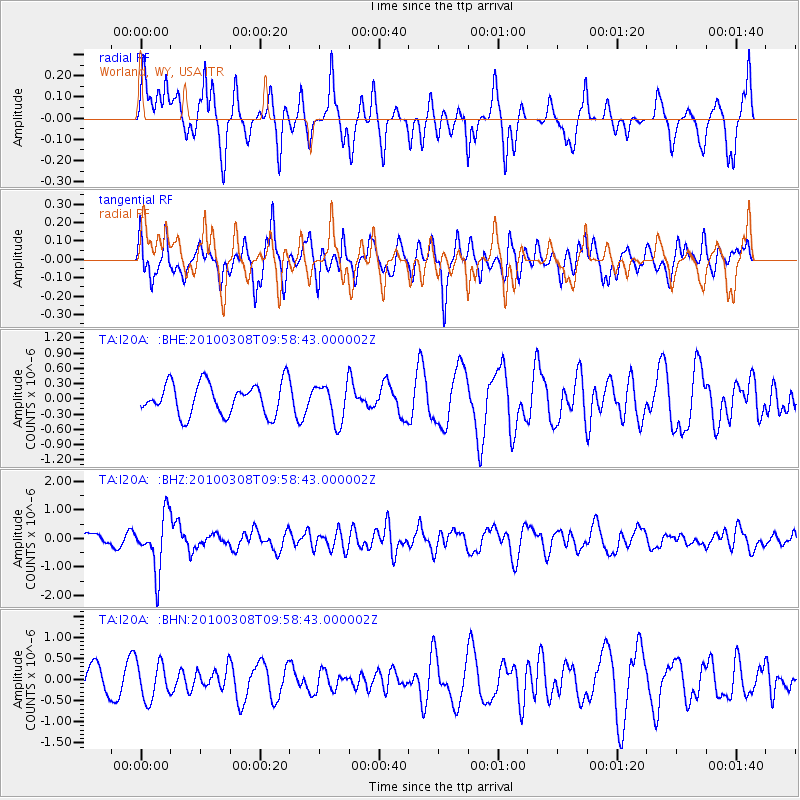
I20A Worland, WY, USA - Earthquake Result Viewer
*The percent match for this event was below the threshold and hence no stack was calculated.
| Earthquake location: |
Mariana Islands |
| Earthquake latitude/longitude: |
19.3/144.7 |
| Earthquake time(UTC): |
2010/03/08 (067) 09:47:11 GMT |
| Earthquake Depth: |
457 km |
| Earthquake Magnitude: |
6.0 MB, 6.1 MW, 6.1 MW |
| Earthquake Catalog/Contributor: |
WHDF/NEIC |
|
| Network: |
TA USArray Transportable Network (new EarthScope stations) |
| Station: |
I20A Worland, WY, USA |
| Lat/Lon: |
43.95 N/108.13 W |
| Elevation: |
1342 m |
|
| Distance: |
88.5 deg |
| Az: |
43.658 deg |
| Baz: |
295.499 deg |
| Ray Param: |
$rayparam |
*The percent match for this event was below the threshold and hence was not used in the summary stack. |
|
| Radial Match: |
51.094196 % |
| Radial Bump: |
298 |
| Transverse Match: |
70.46953 % |
| Transverse Bump: |
400 |
| SOD ConfigId: |
299721 |
| Insert Time: |
2010-04-26 19:45:38.428 +0000 |
| GWidth: |
2.5 |
| Max Bumps: |
400 |
| Tol: |
0.001 |
|
Signal To Noise
| Channel | StoN | STA | LTA |
| TA:I20A: :BHZ:20100308T09:58:43.000002Z | 3.2332587 | 9.557652E-7 | 2.956043E-7 |
| TA:I20A: :BHN:20100308T09:58:43.000002Z | 1.4423317 | 4.3273067E-7 | 3.000216E-7 |
| TA:I20A: :BHE:20100308T09:58:43.000002Z | 1.2061117 | 3.7662906E-7 | 3.1226713E-7 |
| Arrivals |
| Ps | |
| PpPs | |
| PsPs/PpSs | |


