You are here: Home > Network List > XA95 - Missouri to Massachusetts Transect Stations List
> Station MM16 Lake Newton, Illinois > Earthquake Result Viewer
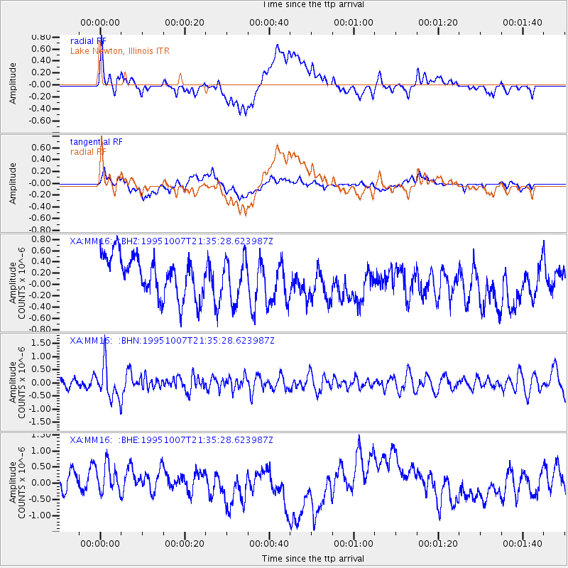
MM16 Lake Newton, Illinois - Earthquake Result Viewer
*The percent match for this event was below the threshold and hence no stack was calculated.
| Earthquake location: |
Peru-Ecuador Border Region |
| Earthquake latitude/longitude: |
-2.8/-77.8 |
| Earthquake time(UTC): |
1995/10/07 (280) 21:28:06 GMT |
| Earthquake Depth: |
33 km |
| Earthquake Magnitude: |
5.8 MB, 5.2 MS, 5.8 UNKNOWN |
| Earthquake Catalog/Contributor: |
WHDF/NEIC |
|
| Network: |
XA Missouri to Massachusetts Transect |
| Station: |
MM16 Lake Newton, Illinois |
| Lat/Lon: |
38.92 N/88.30 W |
| Elevation: |
165 m |
|
| Distance: |
42.6 deg |
| Az: |
347.919 deg |
| Baz: |
164.456 deg |
| Ray Param: |
$rayparam |
*The percent match for this event was below the threshold and hence was not used in the summary stack. |
|
| Radial Match: |
37.337498 % |
| Radial Bump: |
400 |
| Transverse Match: |
42.48968 % |
| Transverse Bump: |
400 |
| SOD ConfigId: |
4480 |
| Insert Time: |
2010-02-26 17:55:49.571 +0000 |
| GWidth: |
2.5 |
| Max Bumps: |
400 |
| Tol: |
0.001 |
|
Signal To Noise
| Channel | StoN | STA | LTA |
| XA:MM16: :BHN:19951007T21:35:28.623987Z | 2.7588193 | 6.7035006E-7 | 2.4298438E-7 |
| XA:MM16: :BHE:19951007T21:35:28.623987Z | 1.3811363 | 5.5171813E-7 | 3.994668E-7 |
| XA:MM16: :BHZ:19951007T21:35:28.623987Z | 1.0433116 | 3.7662093E-7 | 3.6098604E-7 |
| Arrivals |
| Ps | |
| PpPs | |
| PsPs/PpSs | |


