You are here: Home > Network List > US - United States National Seismic Network Stations List
> Station OGNE Ogallala, Nebraska, USA > Earthquake Result Viewer
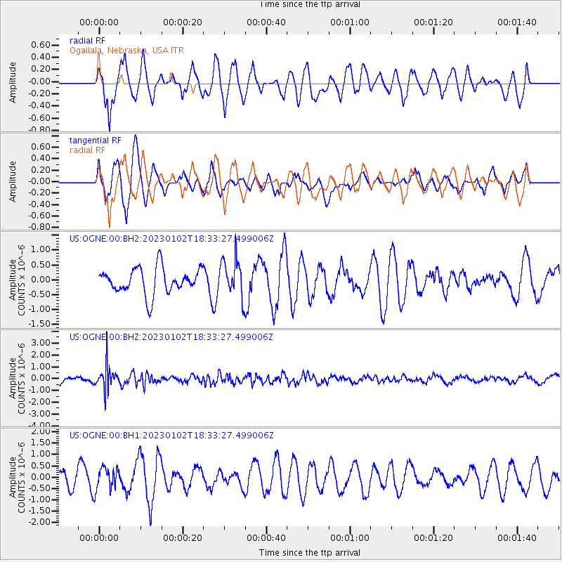
OGNE Ogallala, Nebraska, USA - Earthquake Result Viewer
*The percent match for this event was below the threshold and hence no stack was calculated.
| Earthquake location: |
Kuril Islands |
| Earthquake latitude/longitude: |
46.0/150.8 |
| Earthquake time(UTC): |
2023/01/02 (002) 18:22:45 GMT |
| Earthquake Depth: |
87 km |
| Earthquake Magnitude: |
5.4 Mww |
| Earthquake Catalog/Contributor: |
NEIC PDE/us |
|
| Network: |
US United States National Seismic Network |
| Station: |
OGNE Ogallala, Nebraska, USA |
| Lat/Lon: |
40.95 N/102.03 W |
| Elevation: |
1054 m |
|
| Distance: |
71.8 deg |
| Az: |
49.625 deg |
| Baz: |
315.461 deg |
| Ray Param: |
$rayparam |
*The percent match for this event was below the threshold and hence was not used in the summary stack. |
|
| Radial Match: |
62.8549 % |
| Radial Bump: |
400 |
| Transverse Match: |
62.700943 % |
| Transverse Bump: |
400 |
| SOD ConfigId: |
29823551 |
| Insert Time: |
2023-01-16 18:47:12.797 +0000 |
| GWidth: |
2.5 |
| Max Bumps: |
400 |
| Tol: |
0.001 |
|
Signal To Noise
| Channel | StoN | STA | LTA |
| US:OGNE:00:BHZ:20230102T18:33:27.499006Z | 4.187652 | 9.868032E-7 | 2.3564593E-7 |
| US:OGNE:00:BH1:20230102T18:33:27.499006Z | 0.83080935 | 4.866855E-7 | 5.857969E-7 |
| US:OGNE:00:BH2:20230102T18:33:27.499006Z | 1.5300014 | 6.6074125E-7 | 4.3185665E-7 |
| Arrivals |
| Ps | |
| PpPs | |
| PsPs/PpSs | |


