You are here: Home > Network List > TA - USArray Transportable Network (new EarthScope stations) Stations List
> Station M26A McRoberts Ranch, Bridgeport, NE, USA > Earthquake Result Viewer
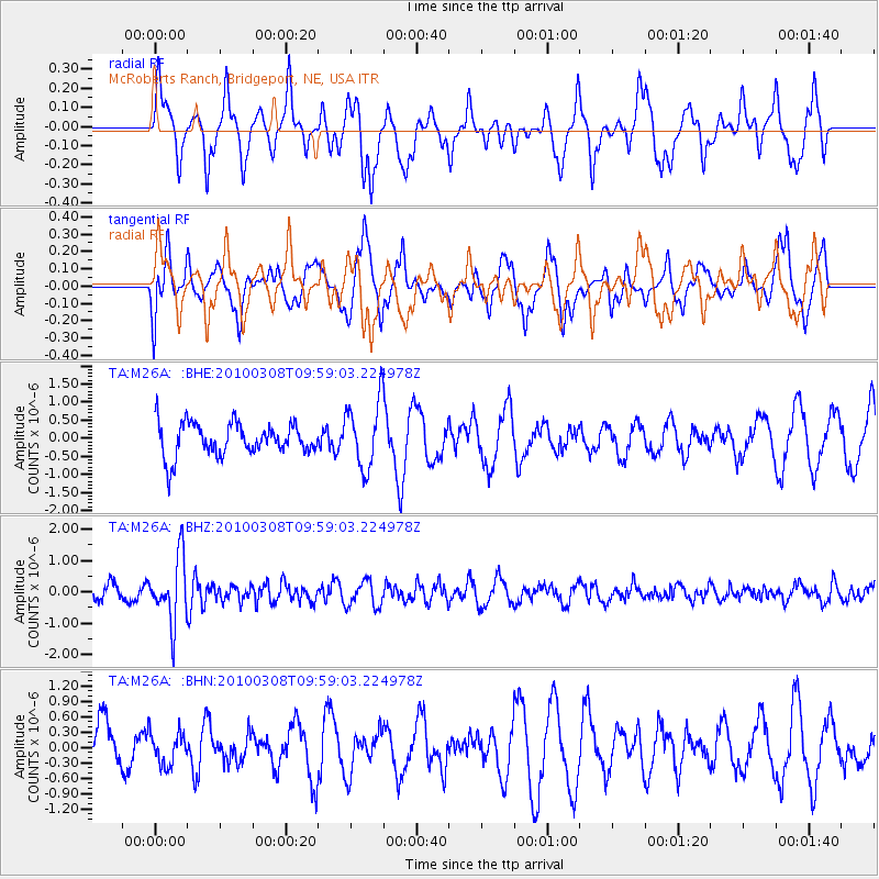
M26A McRoberts Ranch, Bridgeport, NE, USA - Earthquake Result Viewer
*The percent match for this event was below the threshold and hence no stack was calculated.
| Earthquake location: |
Mariana Islands |
| Earthquake latitude/longitude: |
19.3/144.7 |
| Earthquake time(UTC): |
2010/03/08 (067) 09:47:11 GMT |
| Earthquake Depth: |
457 km |
| Earthquake Magnitude: |
6.0 MB, 6.1 MW, 6.1 MW |
| Earthquake Catalog/Contributor: |
WHDF/NEIC |
|
| Network: |
TA USArray Transportable Network (new EarthScope stations) |
| Station: |
M26A McRoberts Ranch, Bridgeport, NE, USA |
| Lat/Lon: |
41.47 N/103.14 W |
| Elevation: |
1348 m |
|
| Distance: |
92.9 deg |
| Az: |
44.186 deg |
| Baz: |
298.864 deg |
| Ray Param: |
$rayparam |
*The percent match for this event was below the threshold and hence was not used in the summary stack. |
|
| Radial Match: |
48.132515 % |
| Radial Bump: |
370 |
| Transverse Match: |
49.595493 % |
| Transverse Bump: |
400 |
| SOD ConfigId: |
299721 |
| Insert Time: |
2010-04-26 19:52:58.577 +0000 |
| GWidth: |
2.5 |
| Max Bumps: |
400 |
| Tol: |
0.001 |
|
Signal To Noise
| Channel | StoN | STA | LTA |
| TA:M26A: :BHZ:20100308T09:59:03.224978Z | 4.5423317 | 1.0373967E-6 | 2.283842E-7 |
| TA:M26A: :BHN:20100308T09:59:03.224978Z | 0.613902 | 3.139894E-7 | 5.1146503E-7 |
| TA:M26A: :BHE:20100308T09:59:03.224978Z | 2.082203 | 9.347602E-7 | 4.4892846E-7 |
| Arrivals |
| Ps | |
| PpPs | |
| PsPs/PpSs | |


