You are here: Home > Network List > TA - USArray Transportable Network (new EarthScope stations) Stations List
> Station P28A Satin Francis, KS, USA > Earthquake Result Viewer
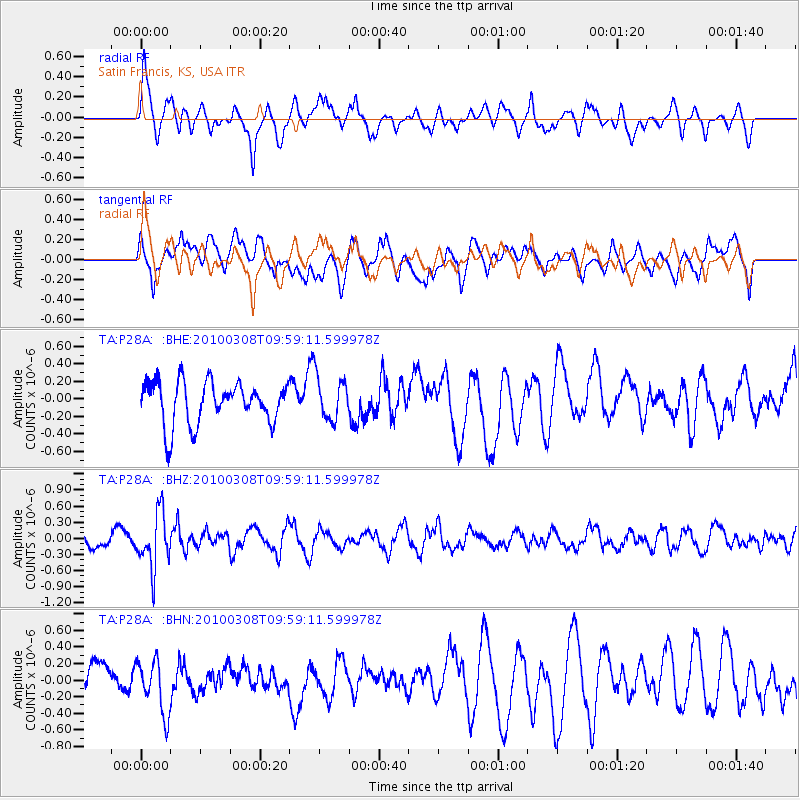
P28A Satin Francis, KS, USA - Earthquake Result Viewer
*The percent match for this event was below the threshold and hence no stack was calculated.
| Earthquake location: |
Mariana Islands |
| Earthquake latitude/longitude: |
19.3/144.7 |
| Earthquake time(UTC): |
2010/03/08 (067) 09:47:11 GMT |
| Earthquake Depth: |
457 km |
| Earthquake Magnitude: |
6.0 MB, 6.1 MW, 6.1 MW |
| Earthquake Catalog/Contributor: |
WHDF/NEIC |
|
| Network: |
TA USArray Transportable Network (new EarthScope stations) |
| Station: |
P28A Satin Francis, KS, USA |
| Lat/Lon: |
39.57 N/101.75 W |
| Elevation: |
1105 m |
|
| Distance: |
94.7 deg |
| Az: |
45.32 deg |
| Baz: |
299.687 deg |
| Ray Param: |
$rayparam |
*The percent match for this event was below the threshold and hence was not used in the summary stack. |
|
| Radial Match: |
50.989044 % |
| Radial Bump: |
400 |
| Transverse Match: |
60.157375 % |
| Transverse Bump: |
400 |
| SOD ConfigId: |
299721 |
| Insert Time: |
2010-04-26 19:55:01.312 +0000 |
| GWidth: |
2.5 |
| Max Bumps: |
400 |
| Tol: |
0.001 |
|
Signal To Noise
| Channel | StoN | STA | LTA |
| TA:P28A: :BHZ:20100308T09:59:11.599978Z | 3.5585074 | 5.1177784E-7 | 1.4381813E-7 |
| TA:P28A: :BHN:20100308T09:59:11.599978Z | 1.0890783 | 3.1682814E-7 | 2.90914E-7 |
| TA:P28A: :BHE:20100308T09:59:11.599978Z | 1.0322092 | 2.4650336E-7 | 2.3881145E-7 |
| Arrivals |
| Ps | |
| PpPs | |
| PsPs/PpSs | |


