You are here: Home > Network List > TA - USArray Transportable Network (new EarthScope stations) Stations List
> Station I28A Midland, SD, USA > Earthquake Result Viewer
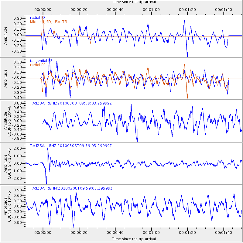
I28A Midland, SD, USA - Earthquake Result Viewer
*The percent match for this event was below the threshold and hence no stack was calculated.
| Earthquake location: |
Mariana Islands |
| Earthquake latitude/longitude: |
19.3/144.7 |
| Earthquake time(UTC): |
2010/03/08 (067) 09:47:11 GMT |
| Earthquake Depth: |
457 km |
| Earthquake Magnitude: |
6.0 MB, 6.1 MW, 6.1 MW |
| Earthquake Catalog/Contributor: |
WHDF/NEIC |
|
| Network: |
TA USArray Transportable Network (new EarthScope stations) |
| Station: |
I28A Midland, SD, USA |
| Lat/Lon: |
44.00 N/101.17 W |
| Elevation: |
655 m |
|
| Distance: |
92.9 deg |
| Az: |
41.262 deg |
| Baz: |
300.347 deg |
| Ray Param: |
$rayparam |
*The percent match for this event was below the threshold and hence was not used in the summary stack. |
|
| Radial Match: |
46.420246 % |
| Radial Bump: |
400 |
| Transverse Match: |
56.797874 % |
| Transverse Bump: |
400 |
| SOD ConfigId: |
299721 |
| Insert Time: |
2010-04-26 19:57:01.857 +0000 |
| GWidth: |
2.5 |
| Max Bumps: |
400 |
| Tol: |
0.001 |
|
Signal To Noise
| Channel | StoN | STA | LTA |
| TA:I28A: :BHZ:20100308T09:59:03.29999Z | 7.380689 | 1.0435743E-6 | 1.4139253E-7 |
| TA:I28A: :BHN:20100308T09:59:03.29999Z | 1.6516718 | 4.0952025E-7 | 2.479429E-7 |
| TA:I28A: :BHE:20100308T09:59:03.29999Z | 1.4992169 | 3.076906E-7 | 2.0523422E-7 |
| Arrivals |
| Ps | |
| PpPs | |
| PsPs/PpSs | |


