You are here: Home > Network List > TA - USArray Transportable Network (new EarthScope stations) Stations List
> Station F27A Lemmon, SD, USA > Earthquake Result Viewer
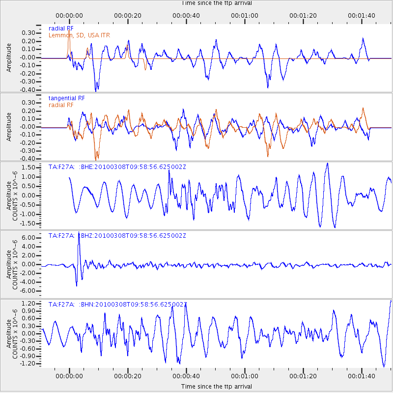
F27A Lemmon, SD, USA - Earthquake Result Viewer
*The percent match for this event was below the threshold and hence no stack was calculated.
| Earthquake location: |
Mariana Islands |
| Earthquake latitude/longitude: |
19.3/144.7 |
| Earthquake time(UTC): |
2010/03/08 (067) 09:47:11 GMT |
| Earthquake Depth: |
457 km |
| Earthquake Magnitude: |
6.0 MB, 6.1 MW, 6.1 MW |
| Earthquake Catalog/Contributor: |
WHDF/NEIC |
|
| Network: |
TA USArray Transportable Network (new EarthScope stations) |
| Station: |
F27A Lemmon, SD, USA |
| Lat/Lon: |
45.87 N/102.02 W |
| Elevation: |
757 m |
|
| Distance: |
91.4 deg |
| Az: |
39.943 deg |
| Baz: |
299.798 deg |
| Ray Param: |
$rayparam |
*The percent match for this event was below the threshold and hence was not used in the summary stack. |
|
| Radial Match: |
56.184265 % |
| Radial Bump: |
395 |
| Transverse Match: |
55.774773 % |
| Transverse Bump: |
400 |
| SOD ConfigId: |
299721 |
| Insert Time: |
2010-04-26 19:58:03.548 +0000 |
| GWidth: |
2.5 |
| Max Bumps: |
400 |
| Tol: |
0.001 |
|
Signal To Noise
| Channel | StoN | STA | LTA |
| TA:F27A: :BHZ:20100308T09:58:56.625002Z | 9.953633 | 2.589802E-6 | 2.6018662E-7 |
| TA:F27A: :BHN:20100308T09:58:56.625002Z | 1.0702269 | 2.574096E-7 | 2.405187E-7 |
| TA:F27A: :BHE:20100308T09:58:56.625002Z | 1.1579102 | 6.195633E-7 | 5.350702E-7 |
| Arrivals |
| Ps | |
| PpPs | |
| PsPs/PpSs | |


