You are here: Home > Network List > TA - USArray Transportable Network (new EarthScope stations) Stations List
> Station G29A Hoven, SD, USA > Earthquake Result Viewer
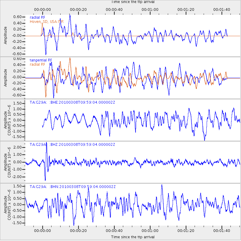
G29A Hoven, SD, USA - Earthquake Result Viewer
*The percent match for this event was below the threshold and hence no stack was calculated.
| Earthquake location: |
Mariana Islands |
| Earthquake latitude/longitude: |
19.3/144.7 |
| Earthquake time(UTC): |
2010/03/08 (067) 09:47:11 GMT |
| Earthquake Depth: |
457 km |
| Earthquake Magnitude: |
6.0 MB, 6.1 MW, 6.1 MW |
| Earthquake Catalog/Contributor: |
WHDF/NEIC |
|
| Network: |
TA USArray Transportable Network (new EarthScope stations) |
| Station: |
G29A Hoven, SD, USA |
| Lat/Lon: |
45.19 N/99.92 W |
| Elevation: |
588 m |
|
| Distance: |
93.1 deg |
| Az: |
39.78 deg |
| Baz: |
301.296 deg |
| Ray Param: |
$rayparam |
*The percent match for this event was below the threshold and hence was not used in the summary stack. |
|
| Radial Match: |
51.867943 % |
| Radial Bump: |
400 |
| Transverse Match: |
62.67646 % |
| Transverse Bump: |
400 |
| SOD ConfigId: |
299721 |
| Insert Time: |
2010-04-26 20:01:28.745 +0000 |
| GWidth: |
2.5 |
| Max Bumps: |
400 |
| Tol: |
0.001 |
|
Signal To Noise
| Channel | StoN | STA | LTA |
| TA:G29A: :BHZ:20100308T09:59:04.000002Z | 6.3332624 | 1.0608541E-6 | 1.6750515E-7 |
| TA:G29A: :BHN:20100308T09:59:04.000002Z | 1.2508874 | 4.859091E-7 | 3.884515E-7 |
| TA:G29A: :BHE:20100308T09:59:04.000002Z | 1.5246112 | 5.952077E-7 | 3.9039966E-7 |
| Arrivals |
| Ps | |
| PpPs | |
| PsPs/PpSs | |


