You are here: Home > Network List > UW - Pacific Northwest Regional Seismic Network Stations List
> Station PASS Maple Falls, WA, USA > Earthquake Result Viewer
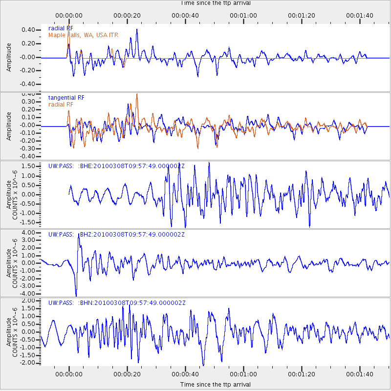
PASS Maple Falls, WA, USA - Earthquake Result Viewer
*The percent match for this event was below the threshold and hence no stack was calculated.
| Earthquake location: |
Mariana Islands |
| Earthquake latitude/longitude: |
19.3/144.7 |
| Earthquake time(UTC): |
2010/03/08 (067) 09:47:11 GMT |
| Earthquake Depth: |
457 km |
| Earthquake Magnitude: |
6.0 MB, 6.1 MW, 6.1 MW |
| Earthquake Catalog/Contributor: |
WHDF/NEIC |
|
| Network: |
UW Pacific Northwest Regional Seismic Network |
| Station: |
PASS Maple Falls, WA, USA |
| Lat/Lon: |
49.00 N/122.09 W |
| Elevation: |
174 m |
|
| Distance: |
77.7 deg |
| Az: |
42.297 deg |
| Baz: |
285.214 deg |
| Ray Param: |
$rayparam |
*The percent match for this event was below the threshold and hence was not used in the summary stack. |
|
| Radial Match: |
79.334564 % |
| Radial Bump: |
400 |
| Transverse Match: |
69.2896 % |
| Transverse Bump: |
400 |
| SOD ConfigId: |
299721 |
| Insert Time: |
2010-04-26 20:07:21.898 +0000 |
| GWidth: |
2.5 |
| Max Bumps: |
400 |
| Tol: |
0.001 |
|
Signal To Noise
| Channel | StoN | STA | LTA |
| UW:PASS: :BHZ:20100308T09:57:49.000002Z | 5.3996634 | 1.9353054E-6 | 3.5841222E-7 |
| UW:PASS: :BHN:20100308T09:57:49.000002Z | 1.1254932 | 4.2297526E-7 | 3.7581324E-7 |
| UW:PASS: :BHE:20100308T09:57:49.000002Z | 2.3937056 | 6.73134E-7 | 2.8121002E-7 |
| Arrivals |
| Ps | |
| PpPs | |
| PsPs/PpSs | |


