You are here: Home > Network List > TA - USArray Transportable Network (new EarthScope stations) Stations List
> Station R27A Eads, CO, USA > Earthquake Result Viewer
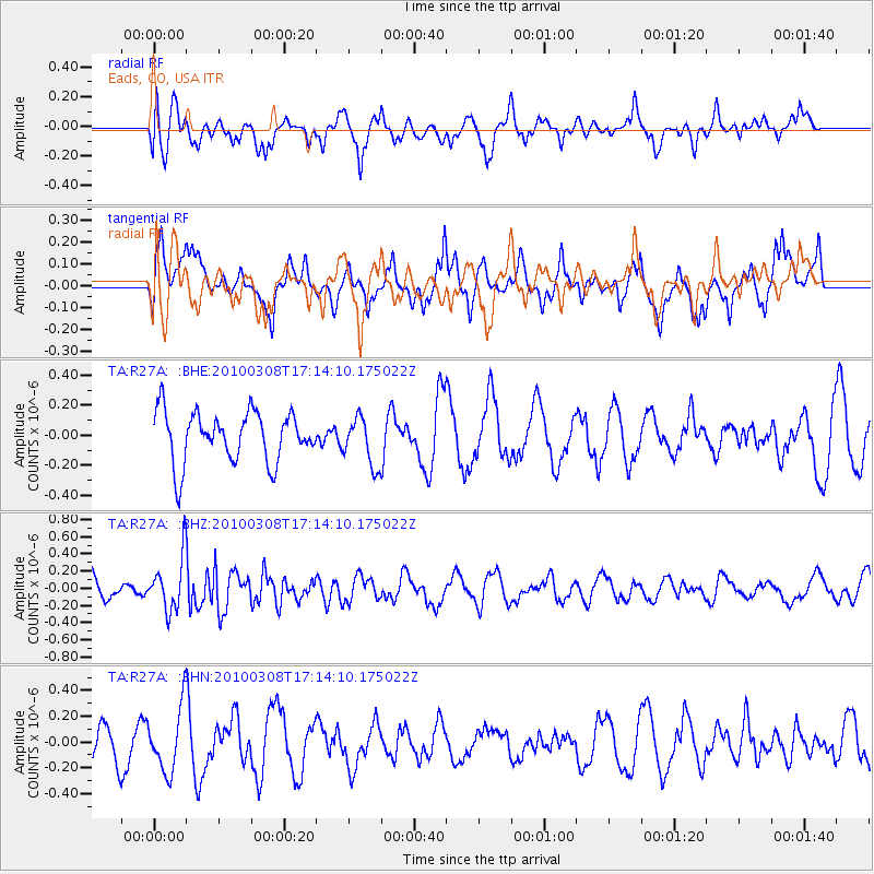
R27A Eads, CO, USA - Earthquake Result Viewer
*The percent match for this event was below the threshold and hence no stack was calculated.
| Earthquake location: |
Salta Province, Argentina |
| Earthquake latitude/longitude: |
-25.7/-66.6 |
| Earthquake time(UTC): |
2010/03/08 (067) 17:03:16 GMT |
| Earthquake Depth: |
10 km |
| Earthquake Magnitude: |
5.6 MB, 5.5 MS, 5.8 MW |
| Earthquake Catalog/Contributor: |
WHDF/NEIC |
|
| Network: |
TA USArray Transportable Network (new EarthScope stations) |
| Station: |
R27A Eads, CO, USA |
| Lat/Lon: |
38.29 N/102.80 W |
| Elevation: |
1201 m |
|
| Distance: |
72.1 deg |
| Az: |
330.785 deg |
| Baz: |
145.976 deg |
| Ray Param: |
$rayparam |
*The percent match for this event was below the threshold and hence was not used in the summary stack. |
|
| Radial Match: |
56.11981 % |
| Radial Bump: |
400 |
| Transverse Match: |
59.717934 % |
| Transverse Bump: |
400 |
| SOD ConfigId: |
299721 |
| Insert Time: |
2010-04-26 20:14:16.924 +0000 |
| GWidth: |
2.5 |
| Max Bumps: |
400 |
| Tol: |
0.001 |
|
Signal To Noise
| Channel | StoN | STA | LTA |
| TA:R27A: :BHZ:20100308T17:14:10.175022Z | 1.8425307 | 3.09699E-7 | 1.6808349E-7 |
| TA:R27A: :BHN:20100308T17:14:10.175022Z | 1.6094832 | 2.4815705E-7 | 1.5418429E-7 |
| TA:R27A: :BHE:20100308T17:14:10.175022Z | 0.9516789 | 1.5950806E-7 | 1.6760703E-7 |
| Arrivals |
| Ps | |
| PpPs | |
| PsPs/PpSs | |


