You are here: Home > Network List > US - United States National Seismic Network Stations List
> Station HAWA Hanford, Washington, USA > Earthquake Result Viewer
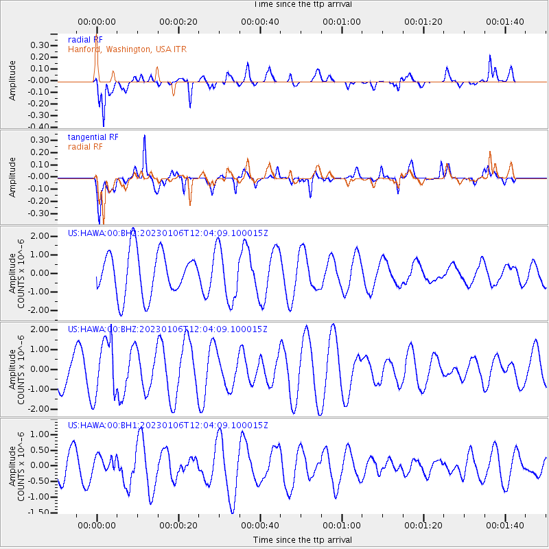
HAWA Hanford, Washington, USA - Earthquake Result Viewer
*The percent match for this event was below the threshold and hence no stack was calculated.
| Earthquake location: |
South Of Fiji Islands |
| Earthquake latitude/longitude: |
-24.8/-179.9 |
| Earthquake time(UTC): |
2023/01/06 (006) 11:52:37 GMT |
| Earthquake Depth: |
505 km |
| Earthquake Magnitude: |
5.9 Mww |
| Earthquake Catalog/Contributor: |
NEIC PDE/us |
|
| Network: |
US United States National Seismic Network |
| Station: |
HAWA Hanford, Washington, USA |
| Lat/Lon: |
46.39 N/119.53 W |
| Elevation: |
364 m |
|
| Distance: |
89.4 deg |
| Az: |
37.009 deg |
| Baz: |
232.25 deg |
| Ray Param: |
$rayparam |
*The percent match for this event was below the threshold and hence was not used in the summary stack. |
|
| Radial Match: |
58.56017 % |
| Radial Bump: |
400 |
| Transverse Match: |
66.86889 % |
| Transverse Bump: |
400 |
| SOD ConfigId: |
29823551 |
| Insert Time: |
2023-01-20 12:09:22.283 +0000 |
| GWidth: |
2.5 |
| Max Bumps: |
400 |
| Tol: |
0.001 |
|
Signal To Noise
| Channel | StoN | STA | LTA |
| US:HAWA:00:BHZ:20230106T12:04:09.100015Z | 2.2598057 | 1.4315953E-6 | 6.3350376E-7 |
| US:HAWA:00:BH1:20230106T12:04:09.100015Z | 0.51176924 | 2.7088998E-7 | 5.293206E-7 |
| US:HAWA:00:BH2:20230106T12:04:09.100015Z | 1.2109855 | 1.4246469E-6 | 1.176436E-6 |
| Arrivals |
| Ps | |
| PpPs | |
| PsPs/PpSs | |


