You are here: Home > Network List > TA - USArray Transportable Network (new EarthScope stations) Stations List
> Station R31A Burdett, KS, USA > Earthquake Result Viewer
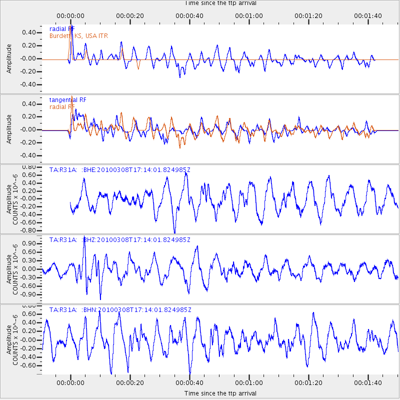
R31A Burdett, KS, USA - Earthquake Result Viewer
*The percent match for this event was below the threshold and hence no stack was calculated.
| Earthquake location: |
Salta Province, Argentina |
| Earthquake latitude/longitude: |
-25.7/-66.6 |
| Earthquake time(UTC): |
2010/03/08 (067) 17:03:16 GMT |
| Earthquake Depth: |
10 km |
| Earthquake Magnitude: |
5.6 MB, 5.5 MS, 5.8 MW |
| Earthquake Catalog/Contributor: |
WHDF/NEIC |
|
| Network: |
TA USArray Transportable Network (new EarthScope stations) |
| Station: |
R31A Burdett, KS, USA |
| Lat/Lon: |
38.29 N/99.53 W |
| Elevation: |
667 m |
|
| Distance: |
70.7 deg |
| Az: |
333.073 deg |
| Baz: |
148.723 deg |
| Ray Param: |
$rayparam |
*The percent match for this event was below the threshold and hence was not used in the summary stack. |
|
| Radial Match: |
59.904118 % |
| Radial Bump: |
400 |
| Transverse Match: |
59.501152 % |
| Transverse Bump: |
400 |
| SOD ConfigId: |
299721 |
| Insert Time: |
2010-04-26 20:18:55.915 +0000 |
| GWidth: |
2.5 |
| Max Bumps: |
400 |
| Tol: |
0.001 |
|
Signal To Noise
| Channel | StoN | STA | LTA |
| TA:R31A: :BHZ:20100308T17:14:01.824985Z | 2.77194 | 3.8640349E-7 | 1.3939821E-7 |
| TA:R31A: :BHN:20100308T17:14:01.824985Z | 1.0701705 | 2.3130237E-7 | 2.1613599E-7 |
| TA:R31A: :BHE:20100308T17:14:01.824985Z | 1.9709506 | 3.5457785E-7 | 1.7990195E-7 |
| Arrivals |
| Ps | |
| PpPs | |
| PsPs/PpSs | |


