You are here: Home > Network List > IW - Intermountain West Stations List
> Station MOOW Moose Ponds, Wyoming, USA > Earthquake Result Viewer
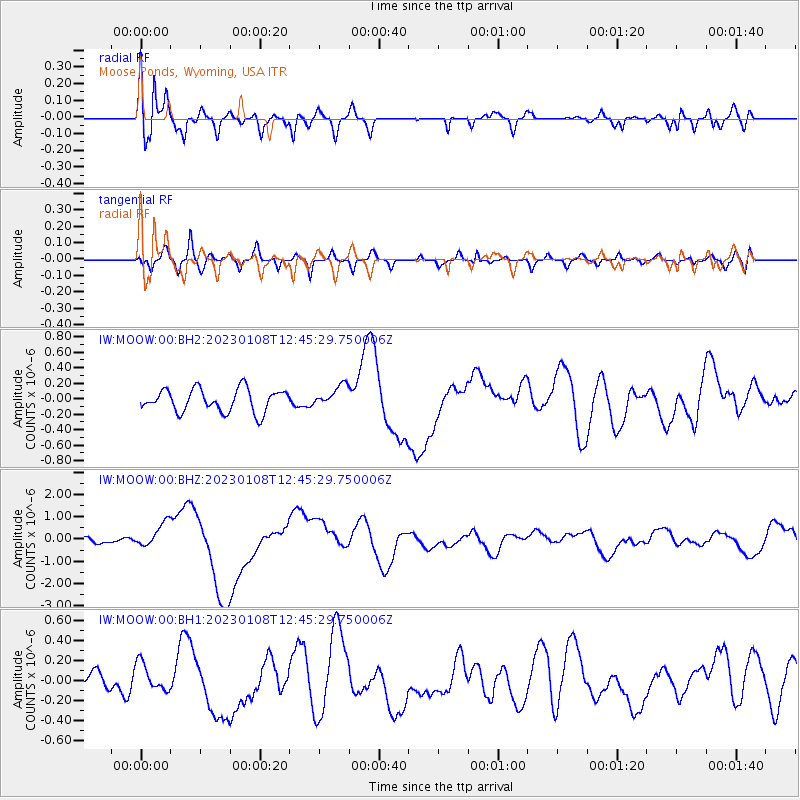
MOOW Moose Ponds, Wyoming, USA - Earthquake Result Viewer
*The percent match for this event was below the threshold and hence no stack was calculated.
| Earthquake location: |
Vanuatu Islands |
| Earthquake latitude/longitude: |
-14.9/166.9 |
| Earthquake time(UTC): |
2023/01/08 (008) 12:32:42 GMT |
| Earthquake Depth: |
28 km |
| Earthquake Magnitude: |
7.0 mww |
| Earthquake Catalog/Contributor: |
NEIC PDE/us |
|
| Network: |
IW Intermountain West |
| Station: |
MOOW Moose Ponds, Wyoming, USA |
| Lat/Lon: |
43.75 N/110.74 W |
| Elevation: |
2128 m |
|
| Distance: |
94.8 deg |
| Az: |
46.122 deg |
| Baz: |
254.04 deg |
| Ray Param: |
$rayparam |
*The percent match for this event was below the threshold and hence was not used in the summary stack. |
|
| Radial Match: |
78.1073 % |
| Radial Bump: |
400 |
| Transverse Match: |
63.940376 % |
| Transverse Bump: |
400 |
| SOD ConfigId: |
29823551 |
| Insert Time: |
2023-01-22 12:49:08.328 +0000 |
| GWidth: |
2.5 |
| Max Bumps: |
400 |
| Tol: |
0.001 |
|
Signal To Noise
| Channel | StoN | STA | LTA |
| IW:MOOW:00:BHZ:20230108T12:45:29.750006Z | 4.6097403 | 5.6805163E-7 | 1.2322856E-7 |
| IW:MOOW:00:BH1:20230108T12:45:29.750006Z | 1.394085 | 1.4171744E-7 | 1.01656234E-7 |
| IW:MOOW:00:BH2:20230108T12:45:29.750006Z | 0.94307715 | 1.3836305E-7 | 1.4671446E-7 |
| Arrivals |
| Ps | |
| PpPs | |
| PsPs/PpSs | |


