You are here: Home > Network List > JP - Japan Meteorological Agency Seismic Network Stations List
> Station YOJ Yonagunijima Island > Earthquake Result Viewer
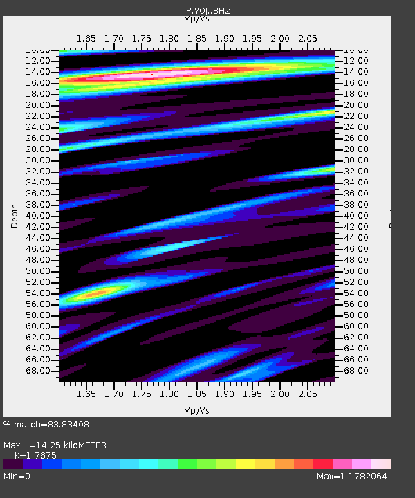
YOJ Yonagunijima Island - Earthquake Result Viewer
| Earthquake location: |
Vanuatu Islands |
| Earthquake latitude/longitude: |
-14.9/166.9 |
| Earthquake time(UTC): |
2023/01/08 (008) 12:32:42 GMT |
| Earthquake Depth: |
28 km |
| Earthquake Magnitude: |
7.0 mww |
| Earthquake Catalog/Contributor: |
NEIC PDE/us |
|
| Network: |
JP Japan Meteorological Agency Seismic Network |
| Station: |
YOJ Yonagunijima Island |
| Lat/Lon: |
24.47 N/123.01 E |
| Elevation: |
32 m |
|
| Distance: |
58.0 deg |
| Az: |
311.892 deg |
| Baz: |
127.846 deg |
| Ray Param: |
0.06307164 |
| Estimated Moho Depth: |
14.25 km |
| Estimated Crust Vp/Vs: |
1.77 |
| Assumed Crust Vp: |
6.183 km/s |
| Estimated Crust Vs: |
3.498 km/s |
| Estimated Crust Poisson's Ratio: |
0.26 |
|
| Radial Match: |
83.83408 % |
| Radial Bump: |
400 |
| Transverse Match: |
67.298515 % |
| Transverse Bump: |
400 |
| SOD ConfigId: |
29823551 |
| Insert Time: |
2023-01-22 12:49:31.866 +0000 |
| GWidth: |
2.5 |
| Max Bumps: |
400 |
| Tol: |
0.001 |
|

Signal To Noise
| Channel | StoN | STA | LTA |
| JP:YOJ: :BHZ:20230108T12:42:01.700018Z | 3.3018534 | 2.2292782E-6 | 6.7515964E-7 |
| JP:YOJ: :BHN:20230108T12:42:01.700018Z | 1.777203 | 9.419082E-7 | 5.299947E-7 |
| JP:YOJ: :BHE:20230108T12:42:01.700018Z | 1.5579146 | 1.0401444E-6 | 6.6765176E-7 |
| Arrivals |
| Ps | 1.9 SECOND |
| PpPs | 6.1 SECOND |
| PsPs/PpSs | 7.9 SECOND |


