You are here: Home > Network List > UW - Pacific Northwest Regional Seismic Network Stations List
> Station BDGR Fisse-Smith Property, Kittitas, WA, USA > Earthquake Result Viewer
BDGR Fisse-Smith Property, Kittitas, WA, USA - Earthquake Result Viewer
| Earthquake location: |
Vanuatu Islands |
| Earthquake latitude/longitude: |
-14.9/166.9 |
| Earthquake time(UTC): |
2023/01/08 (008) 12:32:42 GMT |
| Earthquake Depth: |
28 km |
| Earthquake Magnitude: |
7.0 mww |
| Earthquake Catalog/Contributor: |
NEIC PDE/us |
|
| Network: |
UW Pacific Northwest Regional Seismic Network |
| Station: |
BDGR Fisse-Smith Property, Kittitas, WA, USA |
| Lat/Lon: |
46.86 N/120.30 W |
| Elevation: |
642 m |
|
| Distance: |
89.5 deg |
| Az: |
40.971 deg |
| Baz: |
247.453 deg |
| Ray Param: |
0.041810904 |
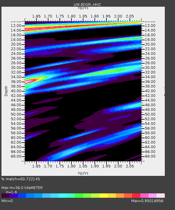
| Estimated Moho Depth: |
36.0 km |
| Estimated Crust Vp/Vs: |
1.60 |
| Assumed Crust Vp: |
6.597 km/s |
| Estimated Crust Vs: |
4.123 km/s |
| Estimated Crust Poisson's Ratio: |
0.18 |
|
| Radial Match: |
80.722145 % |
| Radial Bump: |
361 |
| Transverse Match: |
36.08491 % |
| Transverse Bump: |
400 |
| SOD ConfigId: |
29823551 |
| Insert Time: |
2023-01-22 12:55:24.976 +0000 |
| GWidth: |
2.5 |
| Max Bumps: |
400 |
| Tol: |
0.001 |
|

Signal To Noise
| Channel | StoN | STA | LTA |
| UW:BDGR: :HHZ:20230108T12:45:05.15003Z | 4.412464 | 1.2851475E-6 | 2.912539E-7 |
| UW:BDGR: :HHN:20230108T12:45:05.15003Z | 1.2282257 | 4.8169966E-7 | 3.9219145E-7 |
| UW:BDGR: :HHE:20230108T12:45:05.15003Z | 0.91160977 | 4.399391E-7 | 4.8259585E-7 |
| Arrivals |
| Ps | 3.4 SECOND |
| PpPs | 14 SECOND |
| PsPs/PpSs | 17 SECOND |


