You are here: Home > Network List > UW - Pacific Northwest Regional Seismic Network Stations List
> Station CVILL Solar Farm Field, Colville, WA, USA > Earthquake Result Viewer
CVILL Solar Farm Field, Colville, WA, USA - Earthquake Result Viewer
| Earthquake location: |
Vanuatu Islands |
| Earthquake latitude/longitude: |
-14.9/166.9 |
| Earthquake time(UTC): |
2023/01/08 (008) 12:32:42 GMT |
| Earthquake Depth: |
28 km |
| Earthquake Magnitude: |
7.0 mww |
| Earthquake Catalog/Contributor: |
NEIC PDE/us |
|
| Network: |
UW Pacific Northwest Regional Seismic Network |
| Station: |
CVILL Solar Farm Field, Colville, WA, USA |
| Lat/Lon: |
48.55 N/117.87 W |
| Elevation: |
581 m |
|
| Distance: |
91.6 deg |
| Az: |
39.998 deg |
| Baz: |
249.251 deg |
| Ray Param: |
0.041580845 |
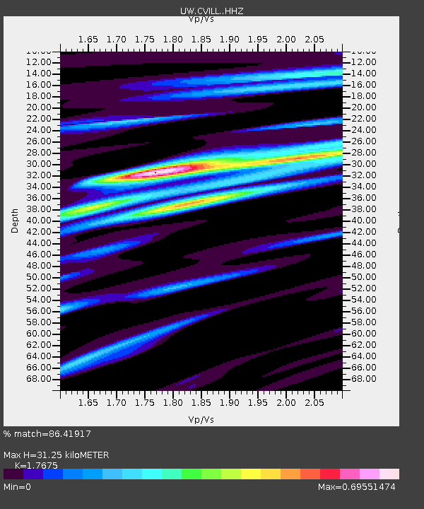
| Estimated Moho Depth: |
31.25 km |
| Estimated Crust Vp/Vs: |
1.77 |
| Assumed Crust Vp: |
6.571 km/s |
| Estimated Crust Vs: |
3.718 km/s |
| Estimated Crust Poisson's Ratio: |
0.26 |
|
| Radial Match: |
86.41917 % |
| Radial Bump: |
400 |
| Transverse Match: |
56.44835 % |
| Transverse Bump: |
400 |
| SOD ConfigId: |
29823551 |
| Insert Time: |
2023-01-22 12:55:45.038 +0000 |
| GWidth: |
2.5 |
| Max Bumps: |
400 |
| Tol: |
0.001 |
|

Signal To Noise
| Channel | StoN | STA | LTA |
| UW:CVILL: :HHZ:20230108T12:45:15.089972Z | 3.1126382 | 7.9318966E-7 | 2.5482873E-7 |
| UW:CVILL: :HHN:20230108T12:45:15.089972Z | 0.8374027 | 2.1214807E-7 | 2.5334054E-7 |
| UW:CVILL: :HHE:20230108T12:45:15.089972Z | 0.99638385 | 2.193506E-7 | 2.2014667E-7 |
| Arrivals |
| Ps | 3.7 SECOND |
| PpPs | 13 SECOND |
| PsPs/PpSs | 17 SECOND |


