You are here: Home > Network List > UW - Pacific Northwest Regional Seismic Network Stations List
> Station DATON Dayton, WA, USA > Earthquake Result Viewer
DATON Dayton, WA, USA - Earthquake Result Viewer
| Earthquake location: |
Vanuatu Islands |
| Earthquake latitude/longitude: |
-14.9/166.9 |
| Earthquake time(UTC): |
2023/01/08 (008) 12:32:42 GMT |
| Earthquake Depth: |
28 km |
| Earthquake Magnitude: |
7.0 mww |
| Earthquake Catalog/Contributor: |
NEIC PDE/us |
|
| Network: |
UW Pacific Northwest Regional Seismic Network |
| Station: |
DATON Dayton, WA, USA |
| Lat/Lon: |
46.26 N/117.93 W |
| Elevation: |
815 m |
|
| Distance: |
90.8 deg |
| Az: |
42.128 deg |
| Baz: |
249.168 deg |
| Ray Param: |
0.041676175 |
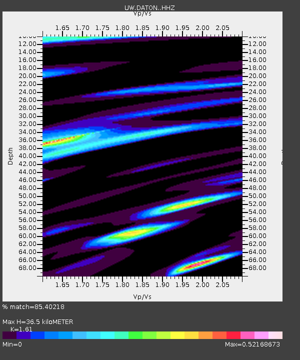
| Estimated Moho Depth: |
36.5 km |
| Estimated Crust Vp/Vs: |
1.61 |
| Assumed Crust Vp: |
6.571 km/s |
| Estimated Crust Vs: |
4.081 km/s |
| Estimated Crust Poisson's Ratio: |
0.19 |
|
| Radial Match: |
85.40218 % |
| Radial Bump: |
400 |
| Transverse Match: |
49.09677 % |
| Transverse Bump: |
400 |
| SOD ConfigId: |
29823551 |
| Insert Time: |
2023-01-22 12:55:45.940 +0000 |
| GWidth: |
2.5 |
| Max Bumps: |
400 |
| Tol: |
0.001 |
|

Signal To Noise
| Channel | StoN | STA | LTA |
| UW:DATON: :HHZ:20230108T12:45:11.179999Z | 2.4303253 | 8.3954086E-7 | 3.454438E-7 |
| UW:DATON: :HHN:20230108T12:45:11.179999Z | 0.9428502 | 2.0560579E-7 | 2.1806835E-7 |
| UW:DATON: :HHE:20230108T12:45:11.179999Z | 1.6647699 | 3.358606E-7 | 2.0174596E-7 |
| Arrivals |
| Ps | 3.5 SECOND |
| PpPs | 14 SECOND |
| PsPs/PpSs | 18 SECOND |


