You are here: Home > Network List > UW - Pacific Northwest Regional Seismic Network Stations List
> Station HOPR Tall Timber Retreat WA > Earthquake Result Viewer
HOPR Tall Timber Retreat WA - Earthquake Result Viewer
| Earthquake location: |
Vanuatu Islands |
| Earthquake latitude/longitude: |
-14.9/166.9 |
| Earthquake time(UTC): |
2023/01/08 (008) 12:32:42 GMT |
| Earthquake Depth: |
28 km |
| Earthquake Magnitude: |
7.0 mww |
| Earthquake Catalog/Contributor: |
NEIC PDE/us |
|
| Network: |
UW Pacific Northwest Regional Seismic Network |
| Station: |
HOPR Tall Timber Retreat WA |
| Lat/Lon: |
47.92 N/120.89 W |
| Elevation: |
597 m |
|
| Distance: |
89.5 deg |
| Az: |
39.832 deg |
| Baz: |
247.005 deg |
| Ray Param: |
0.04178201 |
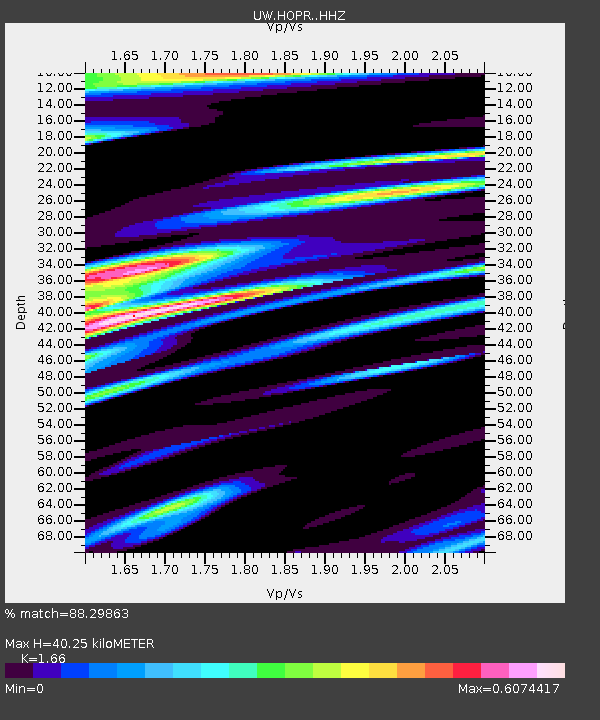
| Estimated Moho Depth: |
40.25 km |
| Estimated Crust Vp/Vs: |
1.66 |
| Assumed Crust Vp: |
6.597 km/s |
| Estimated Crust Vs: |
3.974 km/s |
| Estimated Crust Poisson's Ratio: |
0.22 |
|
| Radial Match: |
88.29863 % |
| Radial Bump: |
400 |
| Transverse Match: |
54.538544 % |
| Transverse Bump: |
400 |
| SOD ConfigId: |
29823551 |
| Insert Time: |
2023-01-22 12:56:14.115 +0000 |
| GWidth: |
2.5 |
| Max Bumps: |
400 |
| Tol: |
0.001 |
|

Signal To Noise
| Channel | StoN | STA | LTA |
| UW:HOPR: :HHZ:20230108T12:45:05.330023Z | 2.5433655 | 8.5966883E-7 | 3.3800444E-7 |
| UW:HOPR: :HHN:20230108T12:45:05.330023Z | 1.2210108 | 2.3685602E-7 | 1.9398357E-7 |
| UW:HOPR: :HHE:20230108T12:45:05.330023Z | 1.9009322 | 3.3260463E-7 | 1.7496923E-7 |
| Arrivals |
| Ps | 4.1 SECOND |
| PpPs | 16 SECOND |
| PsPs/PpSs | 20 SECOND |


