You are here: Home > Network List > US - United States National Seismic Network Stations List
> Station MNTX Cornudas Mountains, Texas, USA > Earthquake Result Viewer
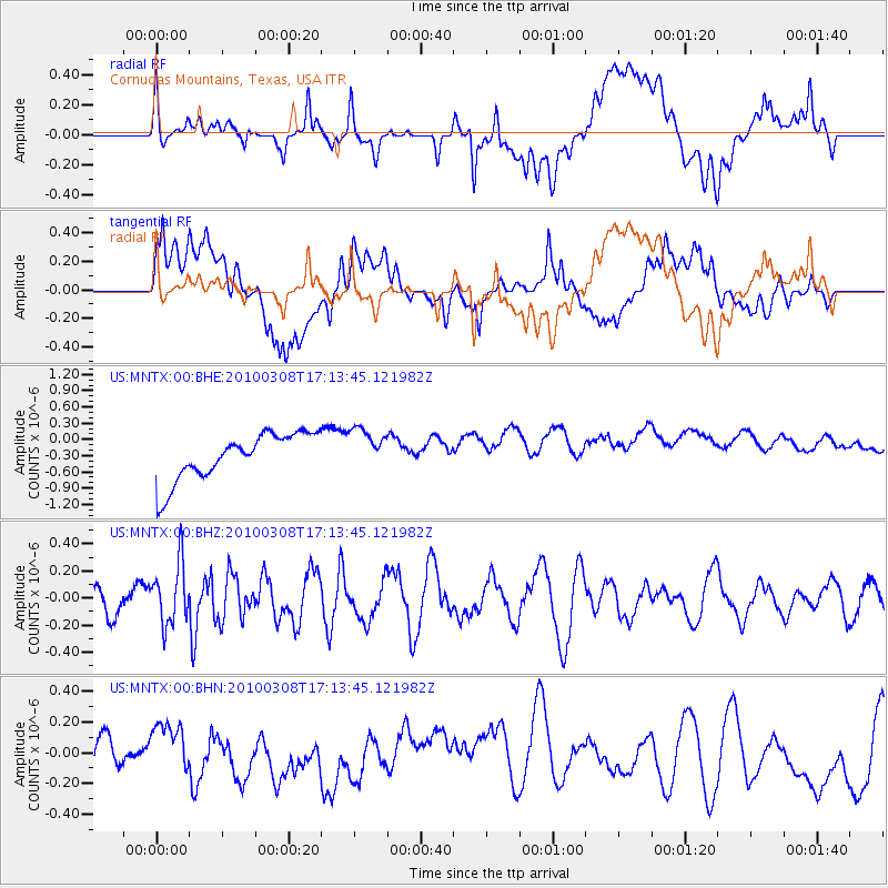
MNTX Cornudas Mountains, Texas, USA - Earthquake Result Viewer
*The percent match for this event was below the threshold and hence no stack was calculated.
| Earthquake location: |
Salta Province, Argentina |
| Earthquake latitude/longitude: |
-25.7/-66.6 |
| Earthquake time(UTC): |
2010/03/08 (067) 17:03:16 GMT |
| Earthquake Depth: |
10 km |
| Earthquake Magnitude: |
5.6 MB, 5.5 MS, 5.8 MW |
| Earthquake Catalog/Contributor: |
WHDF/NEIC |
|
| Network: |
US United States National Seismic Network |
| Station: |
MNTX Cornudas Mountains, Texas, USA |
| Lat/Lon: |
31.70 N/105.38 W |
| Elevation: |
404 m |
|
| Distance: |
68.0 deg |
| Az: |
324.869 deg |
| Baz: |
142.48 deg |
| Ray Param: |
$rayparam |
*The percent match for this event was below the threshold and hence was not used in the summary stack. |
|
| Radial Match: |
37.11632 % |
| Radial Bump: |
400 |
| Transverse Match: |
27.126358 % |
| Transverse Bump: |
400 |
| SOD ConfigId: |
299721 |
| Insert Time: |
2010-04-26 20:29:30.948 +0000 |
| GWidth: |
2.5 |
| Max Bumps: |
400 |
| Tol: |
0.001 |
|
Signal To Noise
| Channel | StoN | STA | LTA |
| US:MNTX:00:BHZ:20100308T17:13:45.121982Z | 1.9491163 | 2.2579887E-7 | 1.15846795E-7 |
| US:MNTX:00:BHN:20100308T17:13:45.121982Z | 0.4289645 | 1.0162998E-7 | 2.3691932E-7 |
| US:MNTX:00:BHE:20100308T17:13:45.121982Z | 0.92025554 | 3.9747027E-7 | 4.3191292E-7 |
| Arrivals |
| Ps | |
| PpPs | |
| PsPs/PpSs | |


