You are here: Home > Network List > US - United States National Seismic Network Stations List
> Station LKWY Lake (Yellowstone--Lake), Wyoming, USA > Earthquake Result Viewer
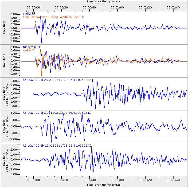
LKWY Lake (Yellowstone--Lake), Wyoming, USA - Earthquake Result Viewer
*The percent match for this event was below the threshold and hence no stack was calculated.
| Earthquake location: |
South Of Mariana Islands |
| Earthquake latitude/longitude: |
13.8/146.5 |
| Earthquake time(UTC): |
2018/02/11 (042) 23:14:18 GMT |
| Earthquake Depth: |
42 km |
| Earthquake Magnitude: |
6.2 Mi |
| Earthquake Catalog/Contributor: |
NEIC PDE/pt |
|
| Network: |
US United States National Seismic Network |
| Station: |
LKWY Lake (Yellowstone--Lake), Wyoming, USA |
| Lat/Lon: |
44.57 N/110.40 W |
| Elevation: |
2424 m |
|
| Distance: |
89.5 deg |
| Az: |
44.13 deg |
| Baz: |
288.88 deg |
| Ray Param: |
$rayparam |
*The percent match for this event was below the threshold and hence was not used in the summary stack. |
|
| Radial Match: |
86.82761 % |
| Radial Bump: |
400 |
| Transverse Match: |
79.88142 % |
| Transverse Bump: |
400 |
| SOD ConfigId: |
2973751 |
| Insert Time: |
2018-10-09 08:06:15.319 +0000 |
| GWidth: |
2.5 |
| Max Bumps: |
400 |
| Tol: |
0.001 |
|
Signal To Noise
| Channel | StoN | STA | LTA |
| US:LKWY:00:BHZ:20180211T23:26:41.025024Z | 0.7629005 | 1.04165665E-7 | 1.36539E-7 |
| US:LKWY:00:BH1:20180211T23:26:41.025024Z | 0.74267536 | 1.3753483E-7 | 1.8518834E-7 |
| US:LKWY:00:BH2:20180211T23:26:41.025024Z | 1.3387258 | 2.7936687E-7 | 2.0868119E-7 |
| Arrivals |
| Ps | |
| PpPs | |
| PsPs/PpSs | |


