You are here: Home > Network List > UW - Pacific Northwest Regional Seismic Network Stations List
> Station TNSKT Tonasket, WA, USA > Earthquake Result Viewer
TNSKT Tonasket, WA, USA - Earthquake Result Viewer
| Earthquake location: |
Vanuatu Islands |
| Earthquake latitude/longitude: |
-14.9/166.9 |
| Earthquake time(UTC): |
2023/01/08 (008) 12:32:42 GMT |
| Earthquake Depth: |
28 km |
| Earthquake Magnitude: |
7.0 mww |
| Earthquake Catalog/Contributor: |
NEIC PDE/us |
|
| Network: |
UW Pacific Northwest Regional Seismic Network |
| Station: |
TNSKT Tonasket, WA, USA |
| Lat/Lon: |
48.72 N/119.44 W |
| Elevation: |
395 m |
|
| Distance: |
90.7 deg |
| Az: |
39.463 deg |
| Baz: |
248.087 deg |
| Ray Param: |
0.041681454 |
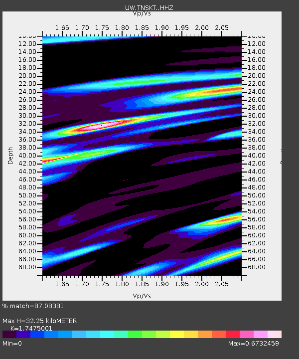
| Estimated Moho Depth: |
32.25 km |
| Estimated Crust Vp/Vs: |
1.75 |
| Assumed Crust Vp: |
6.419 km/s |
| Estimated Crust Vs: |
3.673 km/s |
| Estimated Crust Poisson's Ratio: |
0.26 |
|
| Radial Match: |
87.08381 % |
| Radial Bump: |
400 |
| Transverse Match: |
65.984764 % |
| Transverse Bump: |
400 |
| SOD ConfigId: |
29823551 |
| Insert Time: |
2023-01-22 12:57:39.528 +0000 |
| GWidth: |
2.5 |
| Max Bumps: |
400 |
| Tol: |
0.001 |
|

Signal To Noise
| Channel | StoN | STA | LTA |
| UW:TNSKT: :HHZ:20230108T12:45:10.890021Z | 6.7745957 | 9.630558E-7 | 1.4215694E-7 |
| UW:TNSKT: :HHN:20230108T12:45:10.890021Z | 0.92460537 | 1.829632E-7 | 1.9788247E-7 |
| UW:TNSKT: :HHE:20230108T12:45:10.890021Z | 1.1140599 | 2.4971706E-7 | 2.2415045E-7 |
| Arrivals |
| Ps | 3.8 SECOND |
| PpPs | 14 SECOND |
| PsPs/PpSs | 17 SECOND |


