You are here: Home > Network List > UW - Pacific Northwest Regional Seismic Network Stations List
> Station TWISP Winthrop, WA, USA > Earthquake Result Viewer
TWISP Winthrop, WA, USA - Earthquake Result Viewer
| Earthquake location: |
Vanuatu Islands |
| Earthquake latitude/longitude: |
-14.9/166.9 |
| Earthquake time(UTC): |
2023/01/08 (008) 12:32:42 GMT |
| Earthquake Depth: |
28 km |
| Earthquake Magnitude: |
7.0 mww |
| Earthquake Catalog/Contributor: |
NEIC PDE/us |
|
| Network: |
UW Pacific Northwest Regional Seismic Network |
| Station: |
TWISP Winthrop, WA, USA |
| Lat/Lon: |
48.46 N/120.12 W |
| Elevation: |
756 m |
|
| Distance: |
90.2 deg |
| Az: |
39.535 deg |
| Baz: |
247.58 deg |
| Ray Param: |
0.041716687 |
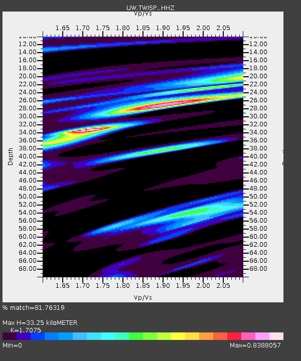
| Estimated Moho Depth: |
33.25 km |
| Estimated Crust Vp/Vs: |
1.71 |
| Assumed Crust Vp: |
6.566 km/s |
| Estimated Crust Vs: |
3.845 km/s |
| Estimated Crust Poisson's Ratio: |
0.24 |
|
| Radial Match: |
81.76319 % |
| Radial Bump: |
400 |
| Transverse Match: |
54.380173 % |
| Transverse Bump: |
400 |
| SOD ConfigId: |
29823551 |
| Insert Time: |
2023-01-22 12:57:45.883 +0000 |
| GWidth: |
2.5 |
| Max Bumps: |
400 |
| Tol: |
0.001 |
|

Signal To Noise
| Channel | StoN | STA | LTA |
| UW:TWISP: :HHZ:20230108T12:45:08.510016Z | 2.0961099 | 6.771498E-7 | 3.230507E-7 |
| UW:TWISP: :HHN:20230108T12:45:08.510016Z | 0.58338094 | 1.4879727E-7 | 2.5506023E-7 |
| UW:TWISP: :HHE:20230108T12:45:08.510016Z | 0.7273366 | 2.77213E-7 | 3.8113438E-7 |
| Arrivals |
| Ps | 3.7 SECOND |
| PpPs | 13 SECOND |
| PsPs/PpSs | 17 SECOND |


