You are here: Home > Network List > WY - Yellowstone Wyoming Seismic Network Stations List
> Station YUF Upper Falls, WY, USA > Earthquake Result Viewer
YUF Upper Falls, WY, USA - Earthquake Result Viewer
| Earthquake location: |
Vanuatu Islands |
| Earthquake latitude/longitude: |
-14.9/166.9 |
| Earthquake time(UTC): |
2023/01/08 (008) 12:32:42 GMT |
| Earthquake Depth: |
28 km |
| Earthquake Magnitude: |
7.0 mww |
| Earthquake Catalog/Contributor: |
NEIC PDE/us |
|
| Network: |
WY Yellowstone Wyoming Seismic Network |
| Station: |
YUF Upper Falls, WY, USA |
| Lat/Lon: |
44.71 N/110.51 W |
| Elevation: |
2394 m |
|
| Distance: |
95.2 deg |
| Az: |
45.237 deg |
| Baz: |
254.28 deg |
| Ray Param: |
0.04083968 |
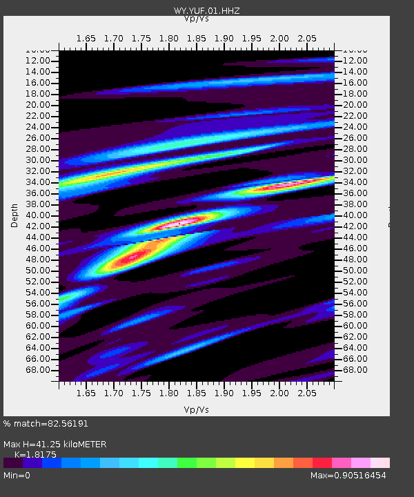
| Estimated Moho Depth: |
41.25 km |
| Estimated Crust Vp/Vs: |
1.82 |
| Assumed Crust Vp: |
6.35 km/s |
| Estimated Crust Vs: |
3.494 km/s |
| Estimated Crust Poisson's Ratio: |
0.28 |
|
| Radial Match: |
82.56191 % |
| Radial Bump: |
400 |
| Transverse Match: |
81.324295 % |
| Transverse Bump: |
400 |
| SOD ConfigId: |
29823551 |
| Insert Time: |
2023-01-22 12:58:11.859 +0000 |
| GWidth: |
2.5 |
| Max Bumps: |
400 |
| Tol: |
0.001 |
|

Signal To Noise
| Channel | StoN | STA | LTA |
| WY:YUF:01:HHZ:20230108T12:45:31.659979Z | 1.9915177 | 4.4824205E-7 | 2.250756E-7 |
| WY:YUF:01:HHN:20230108T12:45:31.659979Z | 0.5332589 | 1.0870735E-7 | 2.0385471E-7 |
| WY:YUF:01:HHE:20230108T12:45:31.659979Z | 1.5472203 | 2.1199128E-7 | 1.3701428E-7 |
| Arrivals |
| Ps | 5.4 SECOND |
| PpPs | 18 SECOND |
| PsPs/PpSs | 23 SECOND |


