You are here: Home > Network List > AK - Alaska Regional Network Stations List
> Station BAT Barry Arm Top, AK, USA > Earthquake Result Viewer
BAT Barry Arm Top, AK, USA - Earthquake Result Viewer
| Earthquake location: |
Tanimbar Islands Reg., Indonesia |
| Earthquake latitude/longitude: |
-7.1/130.0 |
| Earthquake time(UTC): |
2023/01/09 (009) 17:47:34 GMT |
| Earthquake Depth: |
95 km |
| Earthquake Magnitude: |
7.6 mww |
| Earthquake Catalog/Contributor: |
NEIC PDE/us |
|
| Network: |
AK Alaska Regional Network |
| Station: |
BAT Barry Arm Top, AK, USA |
| Lat/Lon: |
61.14 N/148.18 W |
| Elevation: |
1027 m |
|
| Distance: |
92.2 deg |
| Az: |
28.719 deg |
| Baz: |
259.422 deg |
| Ray Param: |
0.04145555 |
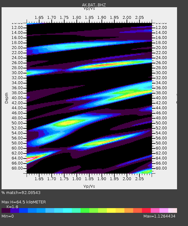
| Estimated Moho Depth: |
64.5 km |
| Estimated Crust Vp/Vs: |
1.60 |
| Assumed Crust Vp: |
6.566 km/s |
| Estimated Crust Vs: |
4.104 km/s |
| Estimated Crust Poisson's Ratio: |
0.18 |
|
| Radial Match: |
92.08543 % |
| Radial Bump: |
400 |
| Transverse Match: |
75.64416 % |
| Transverse Bump: |
400 |
| SOD ConfigId: |
29823551 |
| Insert Time: |
2023-01-23 17:48:32.520 +0000 |
| GWidth: |
2.5 |
| Max Bumps: |
400 |
| Tol: |
0.001 |
|

Signal To Noise
| Channel | StoN | STA | LTA |
| AK:BAT: :BHZ:20230109T18:00:02.079992Z | 3.5227306 | 1.0966935E-6 | 3.1131918E-7 |
| AK:BAT: :BHN:20230109T18:00:02.079992Z | 0.8585028 | 2.2046349E-7 | 2.5679998E-7 |
| AK:BAT: :BHE:20230109T18:00:02.079992Z | 2.2192059 | 7.5769924E-7 | 3.4142812E-7 |
| Arrivals |
| Ps | 6.0 SECOND |
| PpPs | 25 SECOND |
| PsPs/PpSs | 31 SECOND |


